
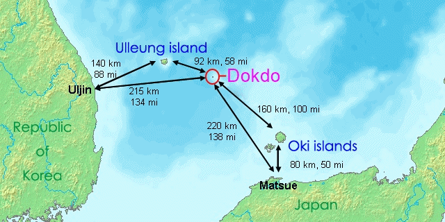
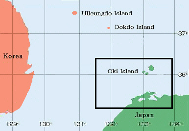
 The following record is yet another piece of evidence that proves Japan did not include Dokdo Island (called Liancourt Rocks by some nations or Takeshima by Japan) from the definition of Japan. The map to the right is an overall map of Korea’s East coast, Ulleungdo Island, Dokdo Island and Japa’s West coast.
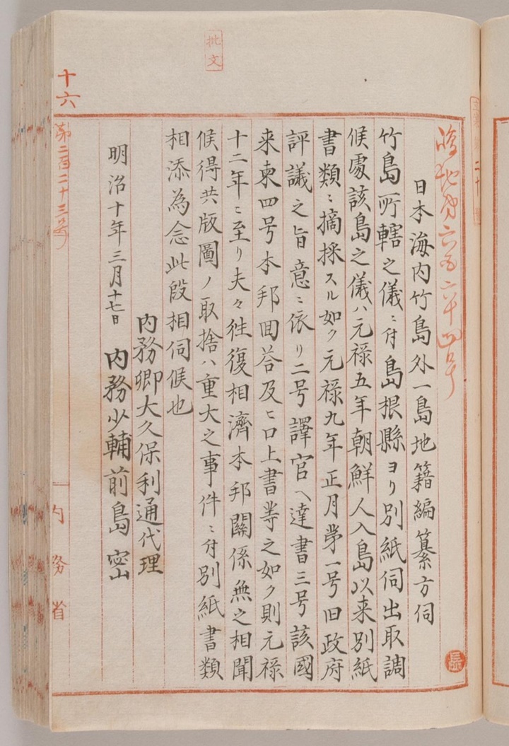
During the formative years of the Meiji Government the Home Ministry began to task of mapping the entire nation of Japan prefecture by prefecture. Of course Japan’s Shimane Prefecture which included the Oki Islands and westermost regions of Japan were included within this process. In the year 1877 Shimane Prefecture inquired to the Home Ministry if Ulleungdo and another island (Dokdo) should be placed under their administrative control. The purpose of this inquiry was to determine which territories were included before mapping Japan.
“…Inquiry regarding the compilation of the cadastre for Takeshima and “another island” in the Sea of Japan…”
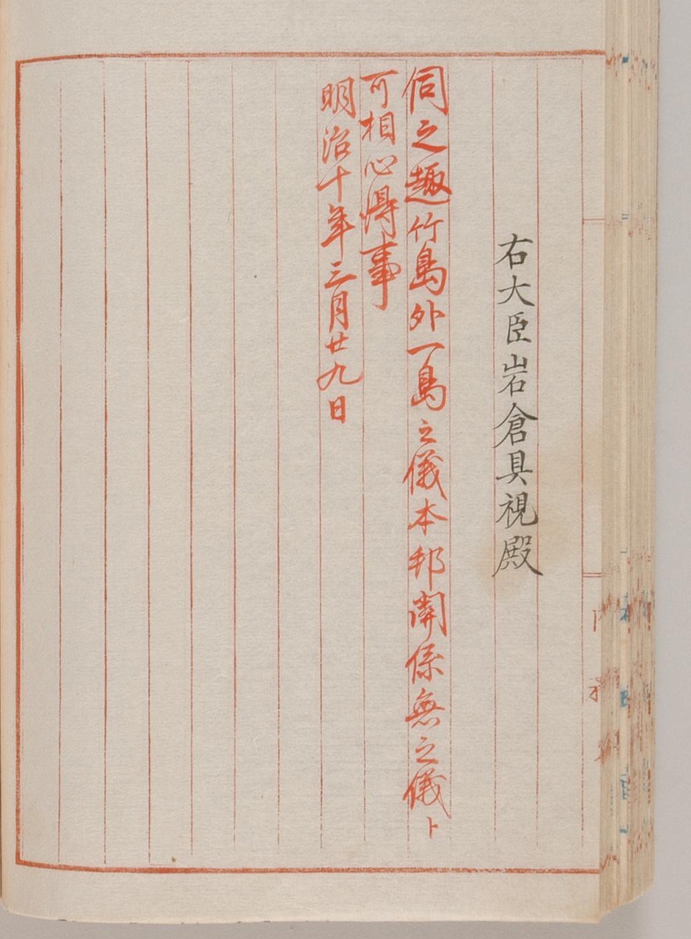
“…Shimane Prefecture sent us an inquiry for a judgement on the jurisdiction of Takeshima as per attachments and this ministry has examined the matter. Regarding the islands in question, they are known to have nothing to do with our country as per documents prepared in the first month of the 9th year of the Genruko (1696) after the entry of the Koreans into the island. 1. the purport of the deliberation by the former government 2. notification of the official interpretor translator 3. the official letter from the country involved 4. our country’s reply and report. In other words by the 12th year of the Genroku, the exchange of instruments had been completed. However, the acquisition or derelection of a territory being of great importance, we request your instruction on this question with the papers attached hereto. March 17th 10th year of Meiji. Acting for the Minister of Home Affairs Okubo Toshimichi, Vice Minister of Home Affairs Meijima Hisoka…”
“…Regarding Takeshima and “other island” it is to be understood that our country has nothing to do with them…”
The disputed area of contention with regard to this document is the ambiguity of the “other island” passage. This is clarified in the attached documents describing both Ulleungdo and the island “next to” it. The maps and documents attached are translated below.
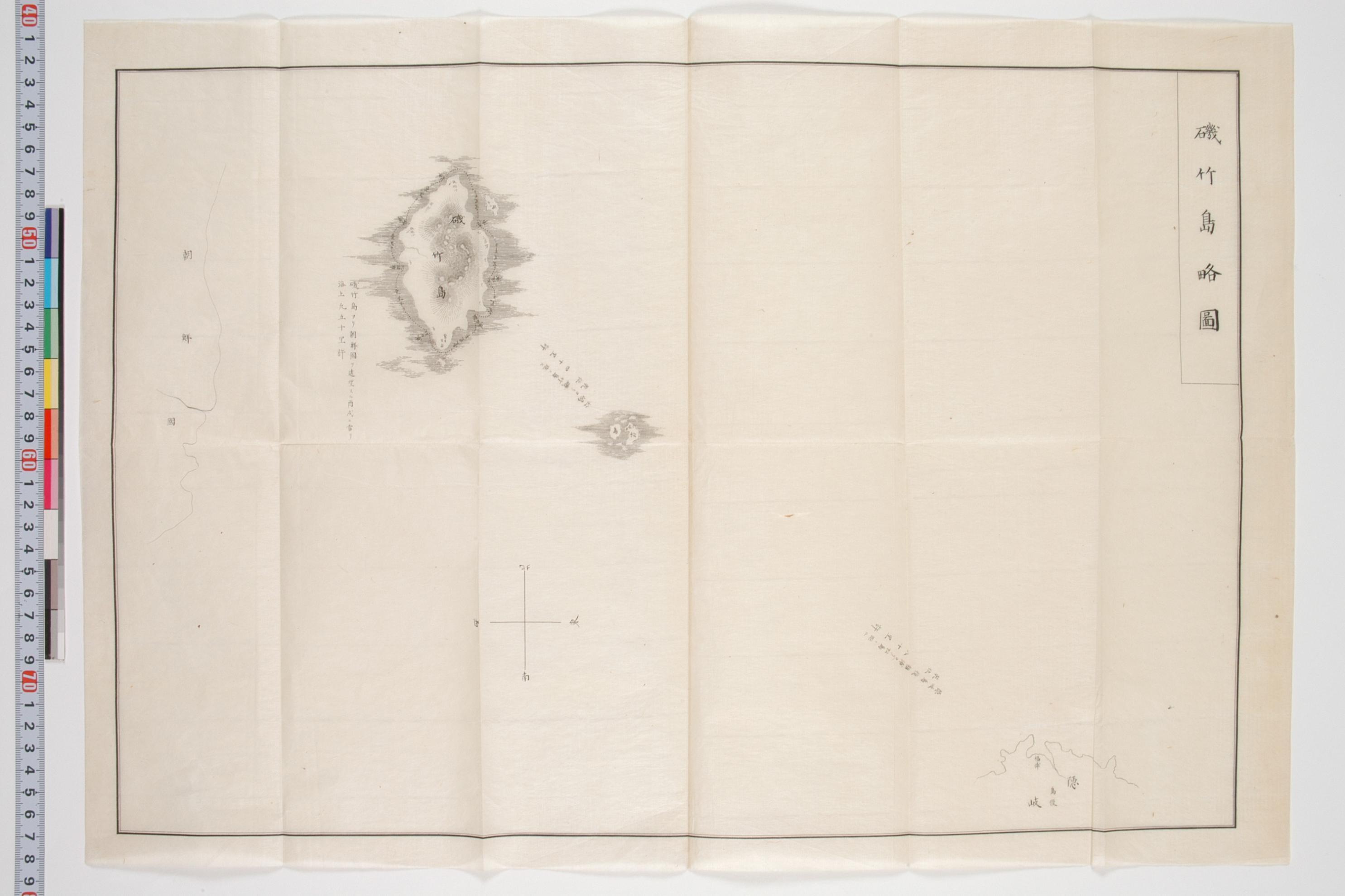
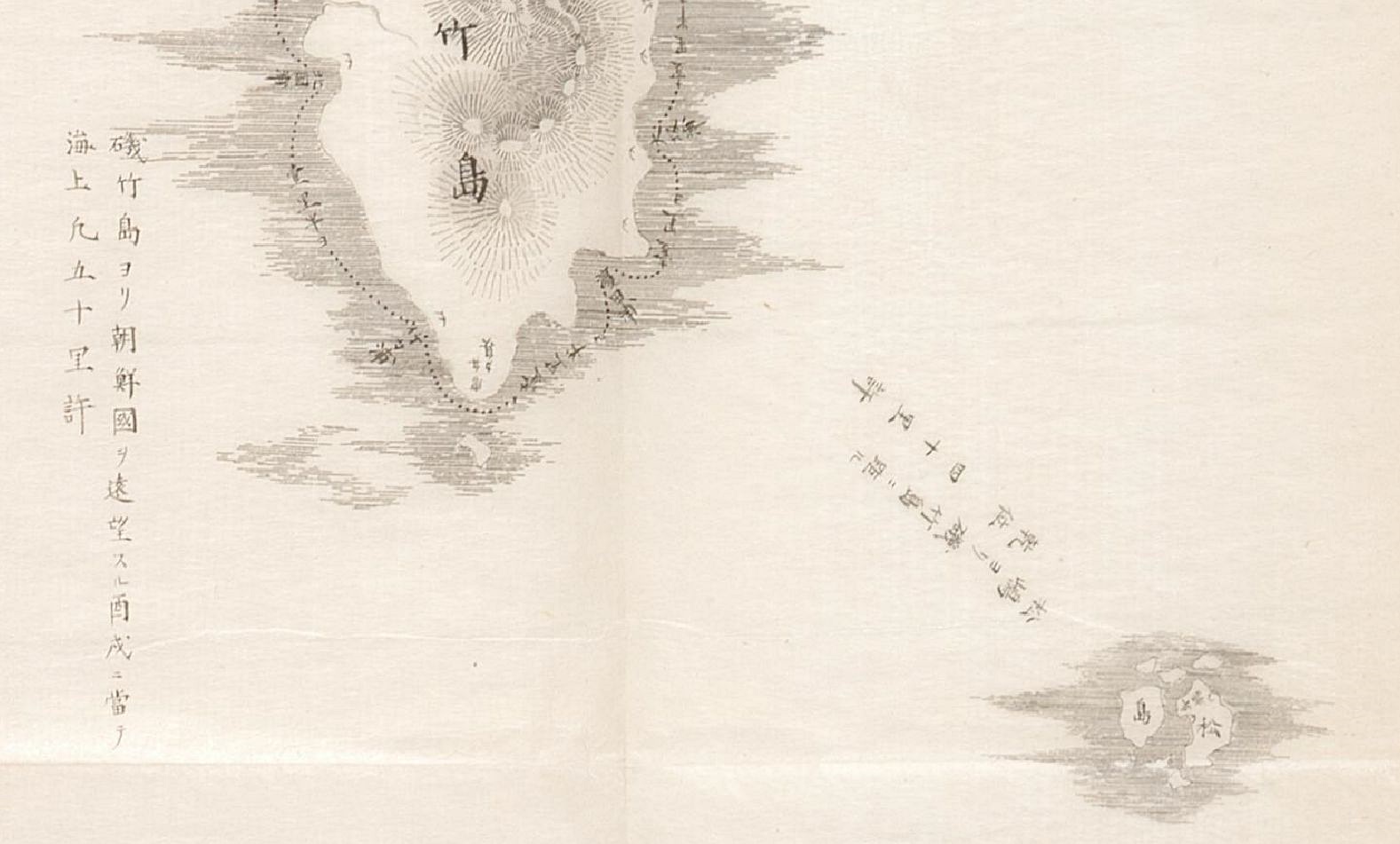
“…磯竹島 (Isotakeshima or Isotakejima) has another name, 竹島 (Takeshima). It is north-west of Oki province (隱岐國) and the distance from Oki is 120 Ri (里). The circumference is 10Ri (里). There is a steep mountain and flat fields are rare. It has three streams and there is a fall also. But, starting points of the streams cannot be seen since valleys are so deep and forest of trees and bamboos are so dense. Plants which catch one’s eye are goryo pines, rose wood, amur cork tree, camellia, oak, paulownia, Wikstroemia sikokiana, southern Japanese hemlock, bamboo, mano bamboo, wild carrot, longstamen onion, Japanese butterbur, Japanese ginger, udo, lily, edible burdock, cherry elaeagnus, raspberry, giant knotweed, Japanese aucuba.
Animals are sea lion, cat, rat, varied tit, pigeon, wild duck, brown-eared bulbul, oriental greenfinch, wild duck, cormoant, swallow, golden eagle, eagle, hawk, nadikoana(?) bird, great tit, and so on. Also found are cinnabar and malachite. Fishes and shellfishes are too many to enumera. (The island) yields sea lions and ear shells. To catch ear shells, in the evening, input bamboo into the sea, and in the morning, ear shells are on the leaves of the bamboo. It is said that the taste is very good. And (we can) obtain several 斗’s(unit of the volume) oils from a sea-lion.
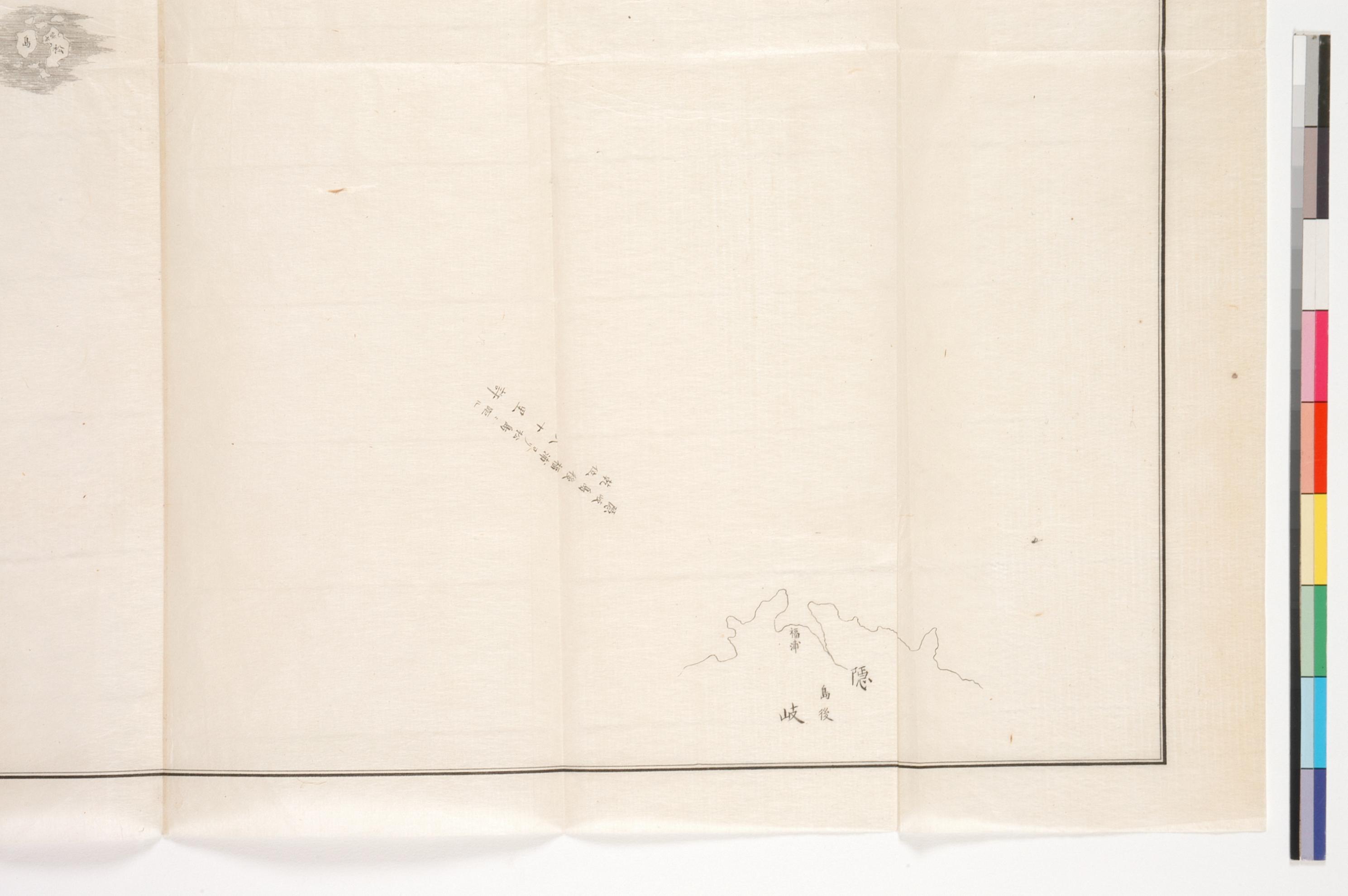
Next, there is “another island” called 松島 (Matsushima). The circumference is 30 Jung( 町), It is on the way to 竹島 (Ulleungdo). The distance from Oki is 80 Ri(里). Trees and a bamboos are rare. (The island) yields fishes and sea lions, too.
No other islands besides Ulleungdo and Dokdo are mentioned in any part of this document.

A more likely scenario is the Japanese were confused about their location. Most interestingly the distance from Korea to Ulleungdo is only 50ri. Nautical ri may have been used on this map because this produces only moderate error of distance and places Ulleungdo in about the same incorrect Easterly location of maps of the mid 1800s due to Seibold’s error. It is also possible very old records were sourced for the distances.
Such an insignificant feature on this map would warrant further explanation on the annexed documents in order to clarify more, but this is not the case. Second the neighboring island’s close proximity to Ulleungdo and small size make territorial ownership unworthy of inquiry.
In short, the only significant “other island” mentioned in this document text is Dokdo (松島) see map right.

On the right side above is a Japanese Fisheries Report published in 1887. This document was related to Oki district of Shimane Prefecture and goes into great detail with regard to the islands of Oki. In addition it defines the islands of Oki as the boundary of this region.
Nowhere in this description is Dokdo mentioned as part of Shimane or Oki regions. Here again it is obvious Japan did not consider Dokdo appended to Shimane and thus was not part of Japan.
To summarize, the Japanese Foreign Ministry has taken the bold stance that Dokdo is an inherent part of Japan from ancient times. This is proven false by studying her own maps and documents from all eras ranging from the 17th Century to the Meiji Era to just a few years before the Japanese annexed Dokdo during the Russo Japanese War of 1905. Japanese scholars’ assertions that the 1877 Kobunruko Documents did not exclude Dokdo from Shimane Prefecture are simply not true.
The Japanese Inquiry made by Shimane Prefecture and the response by the Home Ministry show that no other islands besides Oki Island and Minoshima were considered part of Japan’s Shimane Prefecture. This is further supported by all maps of Shimane Prefecture prior to 1905.