
 To understand better the policy of the Meiji government prior to the annexing of Dokdo, it is necessary to study their internal documents of the late 19th century. What they reveal is contrary to what the Japanese government would like us to believe on several points. The following 1878 document is an inquiry by the Minister of Foreign Affairs Watanabe Kouki regarding ownership of “Matsushima”
“..Who was Watanabe Kuoki..?”
Watanabe Kouki (渡辺洪基), shown to the right, was the Director of the Bureau of Documents in Japan’s Ministry of Foreign Affairs in 1878. The following document details the ongoing debate in the Japanese government over what island was being referred to in the petition submitted to the ministry by Mutoh Heigaku (武藤平学). He wanted to develop Matsushima (Chosun’s Ulleungdo Island). It also explains how the confusion of this man lead to the Japanese Warship Amagi’s survey a short time later. ( see link about Meiji Japan’s Mapping Confusion )
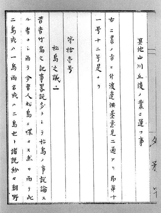
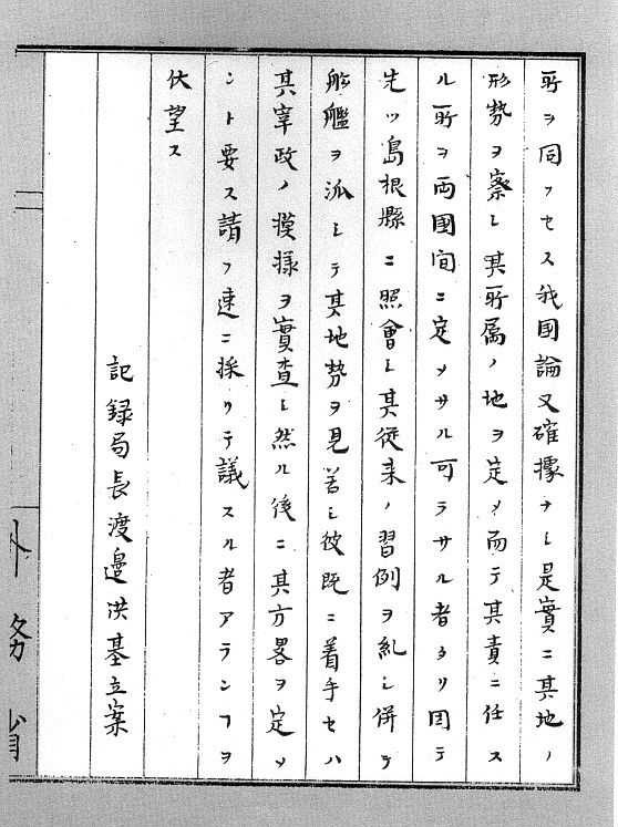
Consideration regarding Matsushima. “A number of brief documents regarding Takeshima (Ulleungdo) can be found from the early days while there is no record discussing Matsushima. Today more and more people are talking about Matsushima, and their opinions are divided over the island. Some say these two islands are one, with two different names and others say they are two separate ones…”
Page 2.
“…Takeshima (Ulleungdo) was given to Chosun by the Shogunate seeking convenience (comfort) at the time instead of considering our future. Therefore if this so-called “Matsushima” turns out to be Takeshima (Ulleungdo) it should belong to them (Chosun) and if not it should be Japan’s property. No one can give us a definite answer. The location of Matsushima is considered critical because it is situated between Chosun and Japan. Nagasaki-Vladisvostok, Shimonseiki-Wonsan Port. Because of Matsushima’s important location English and Russian warships are repeatedly seen in this vicinity. So if it is part of Japan we should be very watchful..”
Page 3.
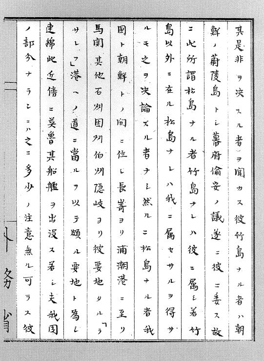
“…Even in the event that it belongs to Chosun we will still have to protect it. In this situation we’re at a loss for answers if/when we are asked by other countries. This leaves the island ownerless. A number of records have stated that “Argonaut” which is a Western name for Takeshima (Ulleungdo) does not exist and that “Dagelet” referring to Matsushima, is Takeshima aka Ulluengdo. So what we call Matsushima, (Dokdo) is called Hornet Rocks by Westerners. But is seems that Westerners actually think of Takeshima when they refer to Matsushima (Ulleungdo). Foreign maps show this “Hornet Rocks” under Japan’s jurisdiction. Yet there is no consensus concerning the other two islands among the countries…”
Page 4.
“…There is no sound basis for our argument, either. Therefore the land and the vicinity should be surveyed which side it belongs to and therefore whose jurisdiction it falls under. Thus we should make an inquiry to Shimane Prefecture and confirm their previous policy on this matter and initiate a survey of the region. If Chosun had already started we need to find out how they are progressing and think what we can do about it. Please I am urging this matter be dealt with as soon as possible…”
Drafted by Watanabe Kuoki (渡辺洪基)
Japanese “scholars” argue Meiji Government documents that declare Takeshima and Matsushima as Chosun territory are not valid because the Meiji government was confused as to which island was which. As Watanabe Kuoki’s above statements show, there were many documents already published that confirmed “Argonaut Island” did not exist. Many Japanese had already verified Matsushima was Ulleungdo originally called Takeshima and the foreign-named “Hornet Rocks” were the islands Japanese referred to as Matsushima – Dokdo.
Japan’s motivation for the annexing of Dokdo 20 years later, can be gleaned from this official paper. Two whole decades before Japan took Dokdo this document sheds light as to why Dokdo, a tiny cluster of rocks, was of major importance to Japan. Watanabe Kuoki was only concerned with establishing a naval presence in the region so the Japanese could monitor and control activity in the Korean Straight. He was particularly concerned about foreign warships.
A disturbing quote in this text is “Even in the event that it belongs to the other side (Chosun) we will still have to protect it….” This quote clearly illustrates some high-ranking officials of the Japanese government wished to assert military control over adjacent islands regardless of who the rightful owner may be. Watanabe Kuoki’s attitude finally prevailed when naval conflicts flared in the region around 1904 and his inquiry foreshadows the eventual 1905 Japanese annexing of Dokdo. ( see Japan’s Military Annexation of Dokdo in Japan’s Takeshima X-Files Series here )
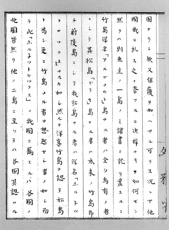
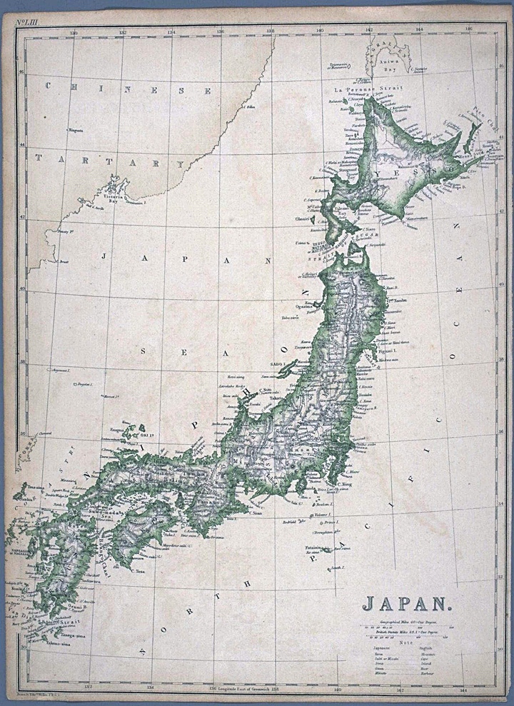 The map to the right drawn by Weller in 1872 is in all probability the chart that Watanabe Kuoki was referencing in the above document. We know he was most likely citing a British map because he used the English name “Hornet Rocks” for Dokdo Island This map incorrectly shows three islands in the East Sea (Sea of Japan)
We should take note, the island drawn as “Takeshima” on this chart is drawn in a vague dashed line. This was a common cartographic technique used to indicate islands which existence was doubtful. This chart shows Hornet Rocks (Liancourt Rocks – Dokdo) as being part of Japan dispite the fact the Japanese did not annex the island for another 25 years, during the Russian – Japanese war of 1904~1905. ( see Japan’s Military Land Appropriation in Korea and Dokdo Series here )
Because of these errors, an investigation was launched and a survey of the region conducted by the Japanese Warship Amagi. It was discovered no other islands existed in the region and the issue of “Matsushima” and Liancourt Rocks was dropped.
These days some Japanese lobbyists insist Watanabe Kuoki’s views were representative of the Japanese Government as whole but in reality nothing could be further from the truth. Watanabe Kuoki was not the head of Japan’s Foreign Affairs but simply an official in charge of the Bureau of Records. He was making his best guess regarding Matshima based on incorrect foreign maps. As his statements show he wrongfully assumed there were three islands in the East Sea (Sea of Japan)
It also should be understood that the Watanbe Kuoki’s opinion regarding the possibility of other islands besides Ulleungdo and Dokdo was the minority view among Japanese Government officials at the time. For example Director of Communications from the Foreign Mininstry Tanabe Taiichi knew from the very beginning that Matsushima was Ulleungdo. Amidst the pros and cons Taiichi stated that if Matushima was Usando its development would not be granted. Another official argued if Matsushima belonged to Chosun its development would amount to an act of aggression.
Ultimately the Japanese Warship Amagi would survey the Ulleungdo region. Although they would wrongly conclude the former Takeshima was Ulleungdo’s neighbour island of Jukdo Islet, wrongful territorial perceptions would be corrected and Japan would continue to exclude Dokdo from their territory. Japanese records would also continue to regard Dokdo as part of Gangwan Province and appended to her neighbour island, Chosun’s Ulleungdo. ( see Dokdo in the Early 20th Century here )