The following pages will detail Japan’s appropriation of land before, during and after the Russo~Japanese war of 1904~1905. The main source of information is Japan’s Center for Historical Records digital archives (JACAR). Through these documents and maps the reader can see how and why Japan “acquired” Dokdo. Also the we will see that Dokdo’s incorporation was really no different than other areas of Korea (and Asia) that were seized for both the Navy’s and Army’s domination of the region. This page will be under constant change and grow in size as more documents are uncovered.
As a result of the coerced February 23rd 1904 Japan Korea Protocol, the Japanese military had troops stationed all over Korea during the Russ-Japanese war. Korean ports, islands and coastal regions were home to Japanese warships, most notably Chinae Port in Chollanamdo, home to Admiral Togo’s fleet. Later in this series we’ll see original Japanese Naval maps of now North Korea’s Wonson showing how heavily mined the port was.
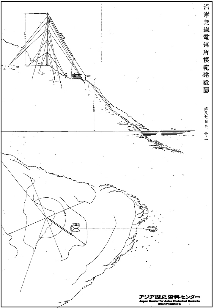
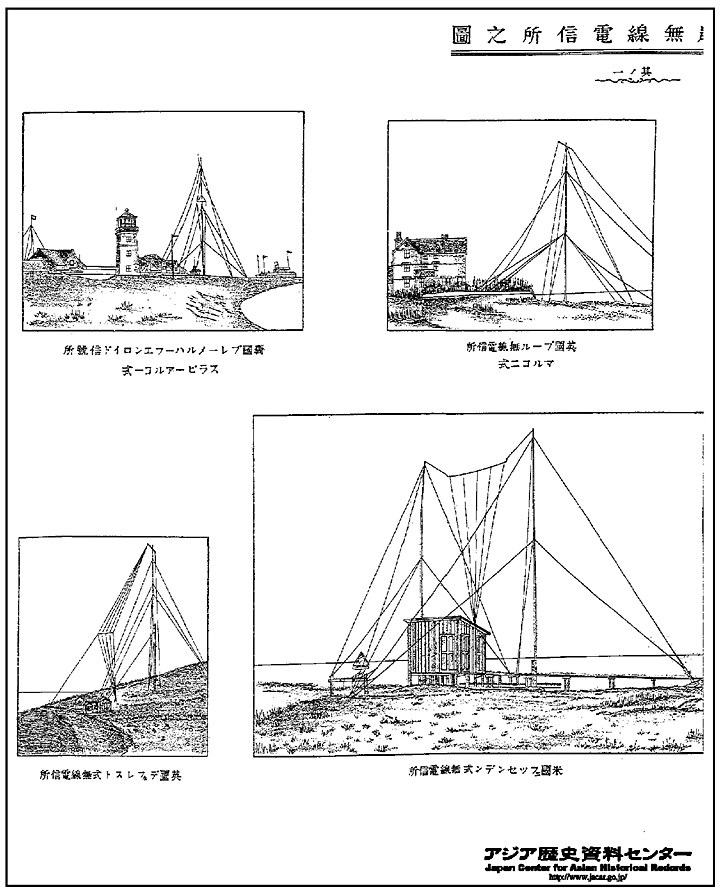
The next images from the Japanese Center for Asian Historical Records, are actual documents showing Japanese military radio systems that were used to monitor the region during the Russo Japanese War of 1904~1905. They are included to give a the reader a more thorough understanding of exactly what the Japanese Navy and Army were illegally installing on Korean territory. These illustrations detailed the proper method for constructing these facilities along with some other examples of systems already in place.
Above are pictures from the same file from the Japanese National Archives that give explicit details of how and where the Japanese Navy surveyed and constructed military facilities on Korean soil and of course on Dokdo Island.
An Original Japanese Map Showing Japan’s Military Base Locations in Korea.
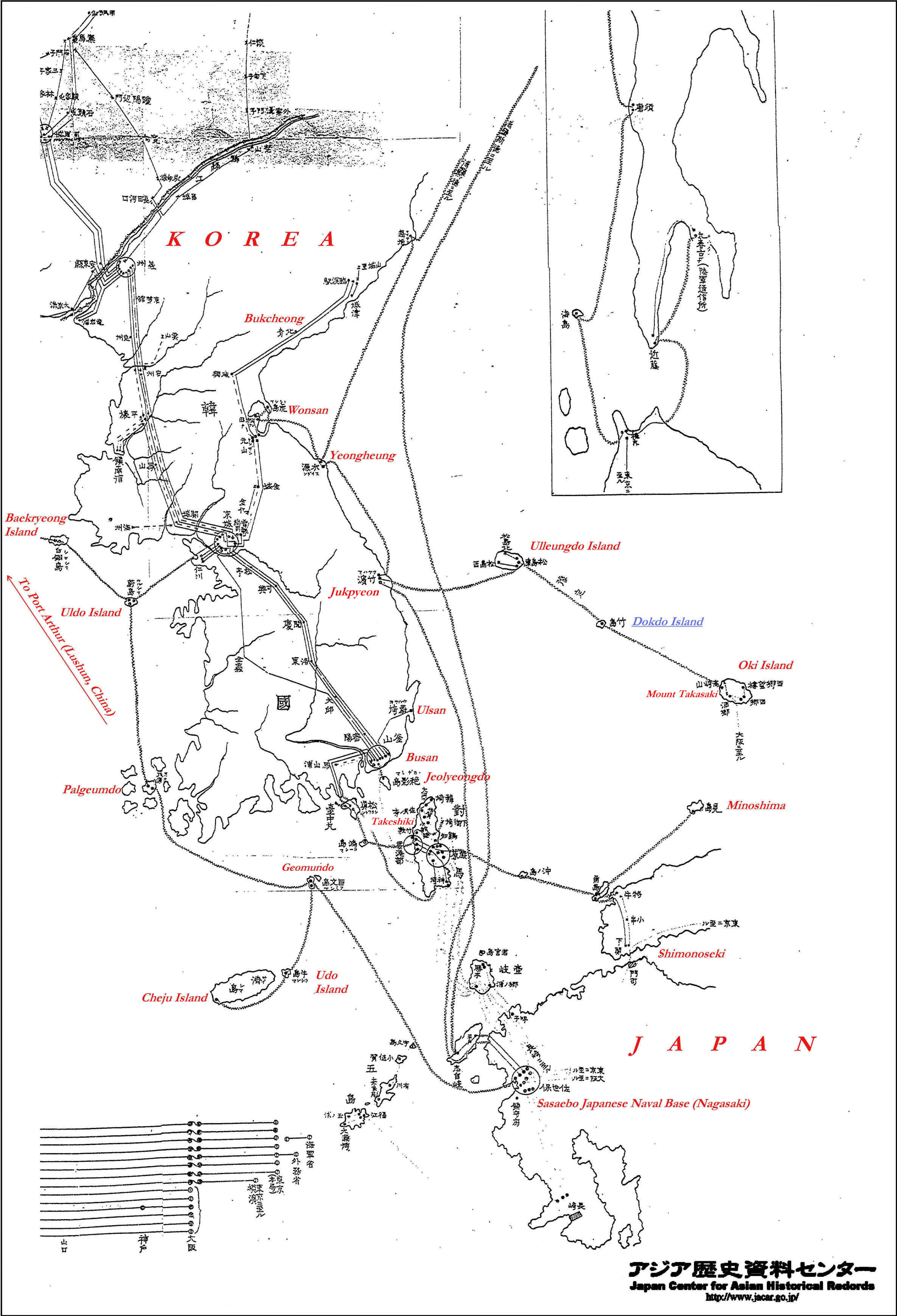
The map to the right is a Japanese Naval map from 1905 and details the underwater and mainland telegraph systems on land and in the sea of Japanese-Korean waterways. The zigzag line connecting the coastal areas is a military underwater cable connecting these areas to send messages to the Japanese Naval base in Sasaebo. (Nagasaki)
The images on this page can be clicked twice for high detail. The red text in English was of course added for reference. Some of the blank image surrounding the maps was cropped to reduce file image and data size. All of these images were sourced from the same file and archives of the Japanese Navy from the 37th and 38th years of the Meiji Government 1904~1905.
We can see Dokdo Island in blue was annexed and immediately incorporated into Japan’s overall naval and army defense plan of the region. The plan would later be revised so that the cables extending form Dokdo Island would bypass Oki Island and instead go to Matsue on the Japanese mainland. (See this map).
When we view the 1904~05 Japanese Naval archives regarding Japanese and Korean coastal areas, a definite pattern emerges. The battle cruisers of the Japanese Navy were sent to all islands of strategic military importance.
On these islands and coastal areas topographical surveys were undertaken to establish to best locations for watchtowers, telegraph stations and for wireless systems.
These were not civilian surveys or facilities and the warships that conducted these affairs were the same ships that massacred the Russian Pacific and Baltic Fleets. The maps to follow will go into detail of the minor islands Japan occupied for military reasons. All of the maps on this page are clickable for a larger image.
Japanese Military Maps of Korea’s Ulleungdo Island
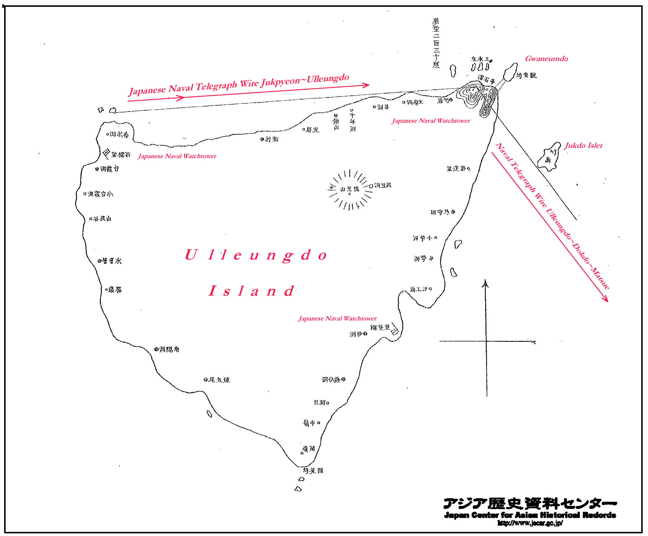
To the left is a Japanese Naval survey map of Korea’s Ulleungdo Island about 130kms East of Korea. Korea’s Ulleungdo Island was a huge strategic asset to the Japanese Navy. Seongin Mountain towered a full kilometer into the sky and offered a 360 degree view that could even reach as far as the Korean mainland on clear days. In addition Ulleungdo was located on the Vladivostok shipping lane positioned toward the valued Tsushima and Chosun Straits.
As a result, Ulleungdo had multiple watchtowers installed and was seen as strategically important by Japan as it also had mooring. Japan had military police stationed on Ulleungdo during the Russo~Japanese War of 1904~1905 but already located police there to control illegal Japanese migrants around the early 1900s.
Ulleungdo’s telegraph lines initially spanned to Jukpyeon Harbor which was where the Japanese warships were anchored. Later as in this map the naval telegraph lines extended to Dokdo~Matsue Japan. Ulleundo and Dokdo’s military importance had long been known by Japanese as shown here. (link)
Japanese Military Maps of Ulleungdo’s Northeast Observaton Post in Seokpo-Ri
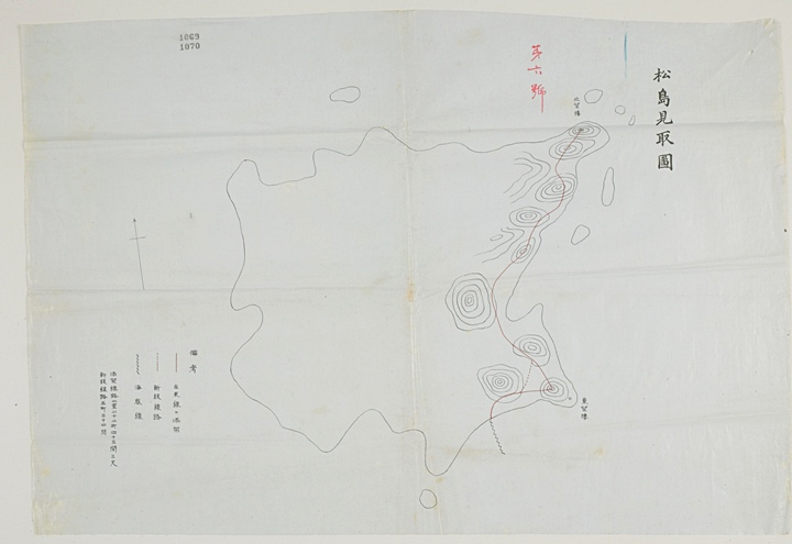
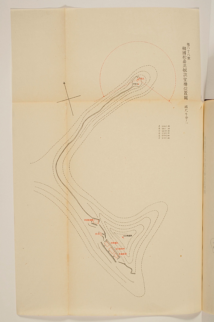
To the right is another Japanese military map of Ulleungdo here labeled as Matsushima (松島). This chart shows the location of Ulleungdo’s northeast watchtower at Seokpo Ri and the southeastern watchtower on Manghyang Mountain (望鄕峰) between Sadong and Dodong. The map shows the path of underwater telegraph lines to be linked to Dokdo and onward to Matsue, Japan.
At the bottom right of the map there is brief legend explaining the symbols on the chart. The zigzag line represents the underwater telegraph lines that were to be networked with Dokdo Island. The rings on the map are contour lines illustrating the numerous mountain ridges to be found on Ulleungdo’s East shore. Dokdo Island has long been known to be visible from Manghyang Mountain and recently photos of Dokdo taken from there have been posted on the internet. (click images for larger view).
Below this text are original map images of the Japanese Naval watchtower installed on Korea’s Ulleungdo Island. It was situated on the mountains of Seok-Po Ri overlooking Cape Gwaneum near Jukdo Islet. The left map shows the watchtower (望樓) and like the maps above, a circular line indicating the range of visibility has been drawn. The map in the center below shows the observation point and wireless transmitter and receiver (無線電信) for the military personnel. The Japanese Naval watchtower at Seok-po was installed about the same time as the one on Dokdo Island.
Above left: This original map shows the location of the Japanese military watch tower at Seok-po on Ulleungdo’s northeast mountain range. Above center: Next to Seok-po’s watchtower were the military barracks for the Japanese soldiers, transmitting and receiving messages etc. Above right: The location at Seok-po provided and excellent view of the East Sea. (click images twice)
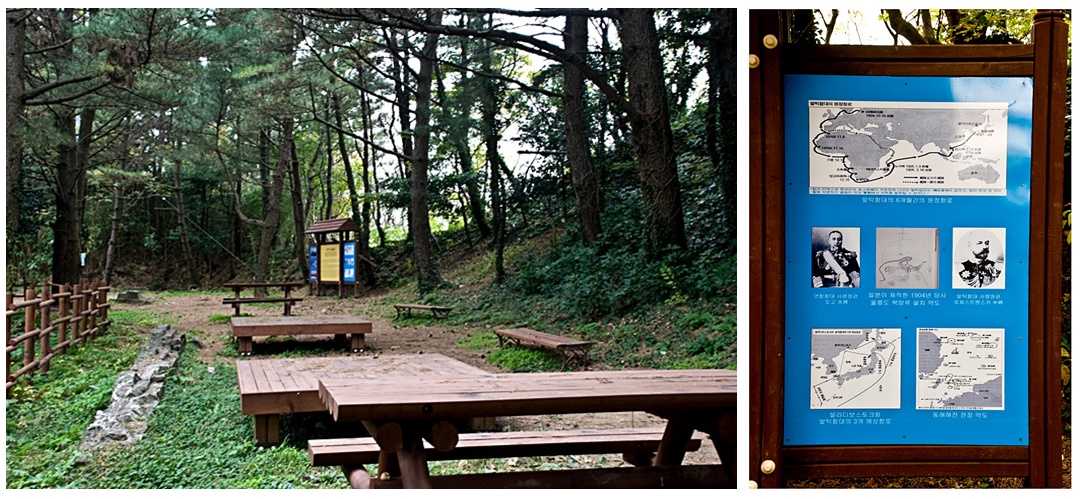
On a lonely hillside on Ulleungdo where few tourists or even locals visit, the remnants of Japan’s military control over Ulleungdo can still be found. The brick foundation of the barracks and a sign explaining the significance of these remains are still visible at Ulleungdo’s Seok-po Ri.
Above left: The remains (left on the ground) of the Japanese watchtower and radio transmitting facilities are still found at Seok-po Ri on Ulleungdo. Above right: A sign written explains the historical circumstances surrounding the ruins can be seen
Through Chukpyeon, Ulleungdo Island, Dokdo Island and finally Oki Island, the Japanese could achieve a band of visibility that would span the length of the East Sea. Those observing the waters were aided with binocluars and could see quite far. For example from Ulluendo’s watchtower Dokdo Island’s form could be easily seen dispite the fact Dokdo is about 90kms away. This was recorded in the logbooks of the Japanese Warship Niitaka in September of 1904. See link.
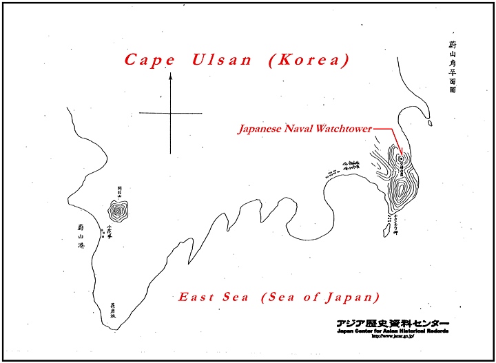
Japanese Military Maps of Korea’s Eastern Ports – Jukbyeon Harbour

Korea’s East Coast was of major importance to the Japanese Navy. This was because they were situated en route to Russia’s Vladivostok Port from which Russian ships harassed Japanese shipping in the summer of 1904. As a result, Ulsan, Busan, Jukbyeon and Wonsan were all occupied by Japanese forces and outfitted with observation towers and radio communications systems. Jukbyeon was a hub of sorts and initially connected the telegraph lines and watchtowers of Ulleungdo to the Japanese Naval base in Sasaebo.
The map to the right is an original Japanese military map of Jukbyeon. It has been labeled in English for the reader to understand some of the features represented. The lower right of the map has a key to indicate where the watchtower and related radio equipment was located.
As with all of these maps the contour lines indicate areas of topography that were best suited for observation and transmission~reception of newly incorporated wireless radio equipment. Wireless radio systems would prove indespensible during the Russo-Japanese war, most notably the Battle of Tsushima which would take place off of Korea’s East coast only months after the drawing of the map above.
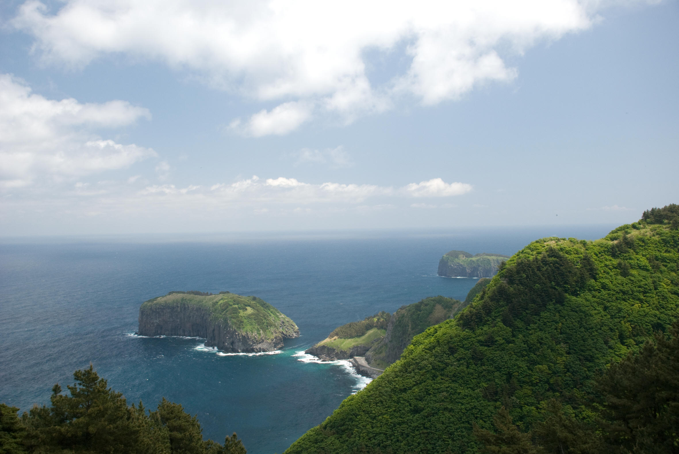
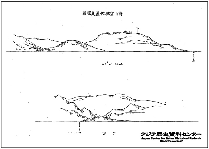
Japanese Military Maps of Korea’s Eastern Ports – Ulsan Harbour
The two maps below this text are of Ulsan Harbor on Korea’s East coast. Like the other maps they have been labeled by the webmaster with red in English for reference. The Japanese mapped Ulsan both from an aerial perspective and from sea level. The map above has contour lines indicating the best topography for watchtowers and radio transmitters. Below shows a profile of Ulsan Harbor. Ulsan’s strategic importance was apparent during the Battle of Ulsan on August 14, 1904. This took place after Russian Naval ships attacked Japanese transport vessels. To the South was Busan’s watchtower and telegraph station and to the North was Jukbyeon’s military base. Ulsan’s watchtower location is on this map.
Japanese Military Land Appropriation in Korea and Dokdo Continued on Next Page…