 Page two of this series will continue to detail Japan’s appropriation of land before, during and after the Russo~Japanese war of 1904~1905. The main source of information is Japan’s Center for Historical Records digital archives (JACAR). Through these documents and maps the reader can see how and why Japan “acquired” Dokdo. Also the we will see that Dokdo’s incorporation was really no different than other areas of Korea (and Asia) that were seized for both the Navy’s and Army’s domination of the region. This page will be under constant change and grow in size as more documents are uncovered.
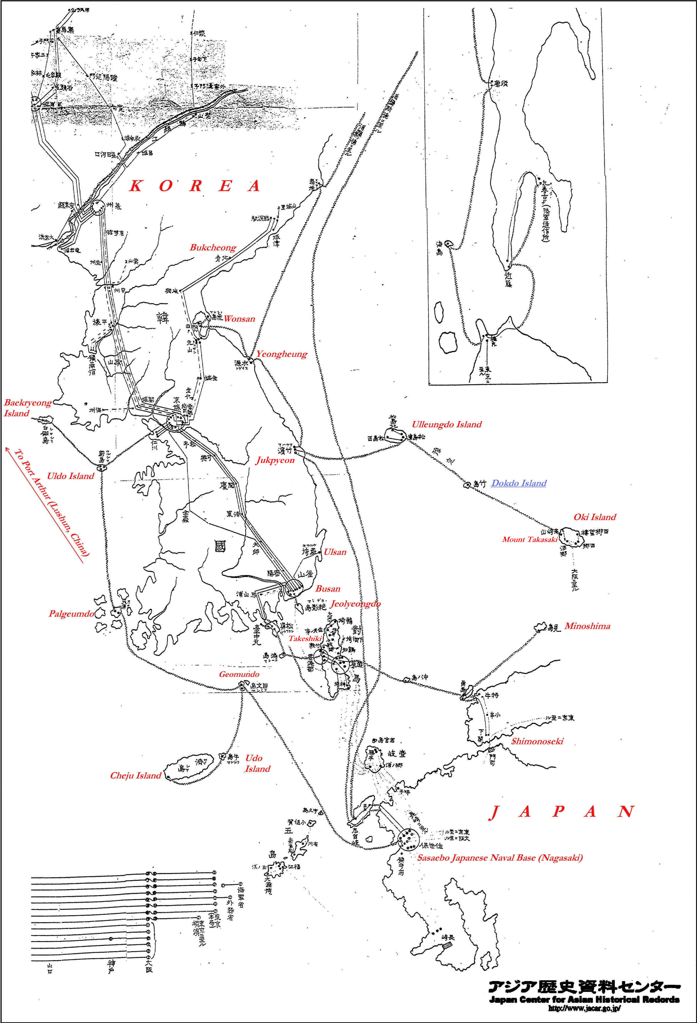
The map to the right is another original Japanese military map. Points of interest have also been highlighted with red letters in English for the reader. The chart is useful because the reader can use it to reference the location of each map to follow. All of these maps are quite large and are clickable for high detail.
The zigzag line connecting the coastal areas is a military underwater cable connecting these areas to send messages to the Japanese Naval base in Sasaebo. (Nagasaki) All of these images were sourced from the same file and archives of the Japanese Navy from the 37th and 38th years of the Meiji Government 1904~1905.
We can see Dokdo Island in blue was annexed and immediately incorporated into Japan’s overall naval and army defense plan of the region. The plan would later be revised so that the cables extending form Dokdo Island would bypass Oki Island and instead go to Matsue on the Japanese mainland.
When we view the 1904~05 Japanese Naval archives regarding Japanese and Korean coastal areas, a definite pattern emerges. The battle cruisers of the Japanese Navy were sent to all islands of strategic military importance. On these islands and coastal areas topographical surveys were undertaken to establish to best locations for watchtowers, telegraph stations and for wireless systems.
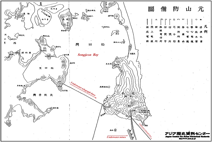
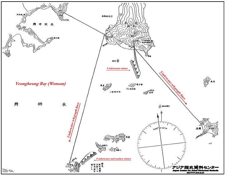
In April 1904, under the flag of Rear Admiral Essen and escorted by destroyers, Russian battle cruisers made a raid on Wonsan, destroying two Japanese coastal vessels and the troop carrier Kinshu-Maru with its assault troops still on board. The maps below illustrate the Japanese Navy’s defensive measures to these raids. Wonsan as shown here was linked by submarine cables to the south and by land telegraph telegraph almost the border between Korea and Russia. These maps are interesting in that not only do they show the underwater telegraph cables but they also include the position of both surface and underwater explosive mines to deter the Russian Navy.
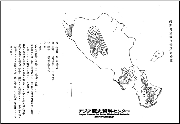 As the title suggests this island was surveyed for building watchtowers and telegraph lines on Jeolyeongdo near Pusan harbour. Admiral Togo’s fleet would lie in wait near this area for the Russian Baltic Fleet to approach the Tsushima Straits in the Battle of Tsushima in 1905. As with all of these maps the maps had a key to the side of the territory surveyed and described where to locate watchtowers and wireless transmitter antennas.
This map has a legend on the right side. A marks the signal facilities, the B on the maps legend marks the watchtower (望樓) and D indicates the source of potable water. Of course the southern tip facing the Chosun Straits was chosen as the ideal spot for these military outposts and weather pending could offer a good view of the narrow band of water between Korea and Tsushima Island. To this day, Jeolyeongdo’s ideal coastal position is used for a lighthouse in what is now part of Busan.

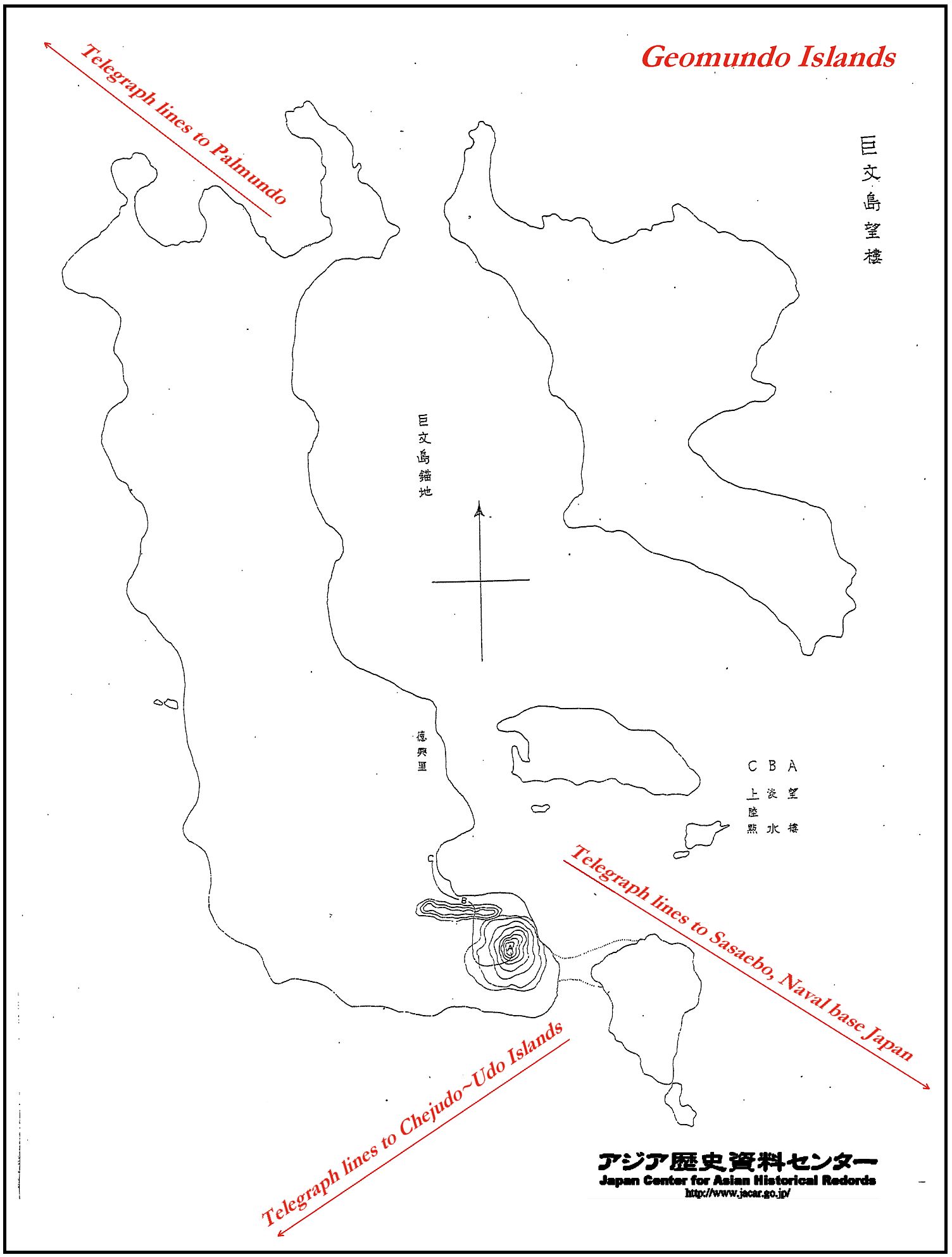
Geomundo’s strategic importance had been known long before the Japanese controlled the islets in 1905. The Americans proposed to build a base there in 1884. In April 1885, Port Hamilton was occupied by three ships of the British Royal Navy on orders from the Admiralty. This was to forestall Russian advances in the face of the Panjdeh Incident in Afghanistan. Port Hamilton served as a counterbalance to the Russian naval base at Vladivostok. By occupying Port Hamilton, the British could prevent Russian advances in east Asia, and block Russian naval activity in the Korea Strait.

Uldo Island much like Dokdo, is a tiny isolated rock located on Korea’s West coast. Likewise, it was Uldo’s location that made this island of strategic value. Uldo could be used to guard and monitor against ships from the West in particular hostile Russian ships stationed in Port Arthur (Lushun). This island could was used to protect the Han River estuary and Incheon Harbour area from invasion. Telegraph lines were installed from Uldo to Baekryeongdo Island and then onward to Port Arthur after the besieged city fell to the Japanese during the Russo~Japanese War. Like all of the Japanese military maps of this series a legend indicated the watchtower location shown on the South end of Uldo Island.
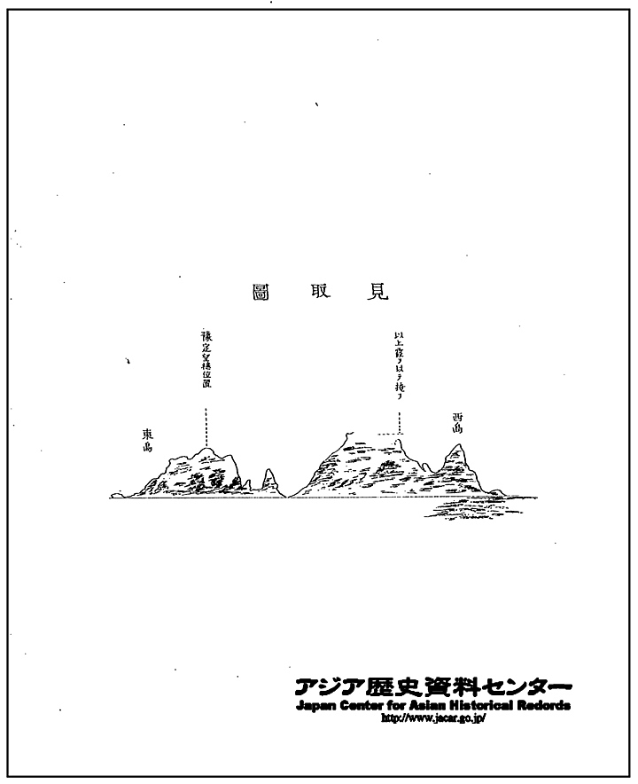
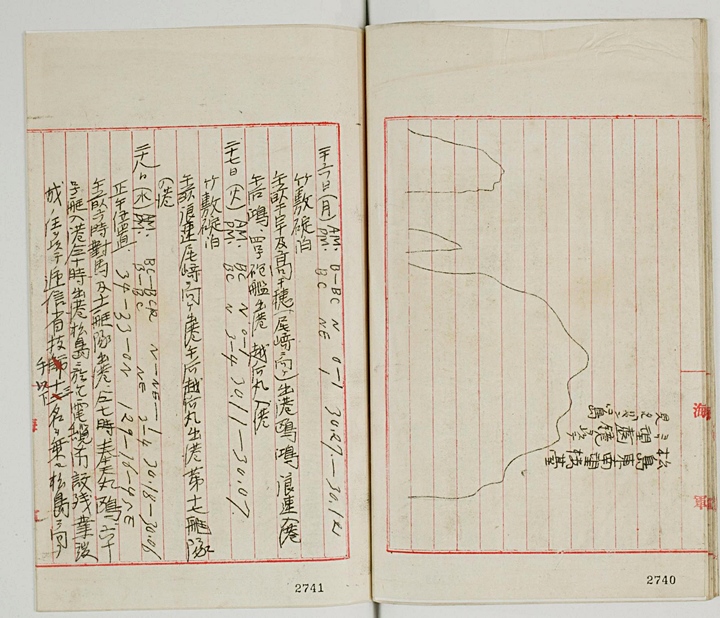 The first mention of the Japanese military’s use for Dokdo Island was in September of 1904 by the Japanese Imperial Warship Niitaka. (shown to the right) Later, it was said the island was suitable for building (military) structures. This first image of Dokdo was little more than a crude sketch of Dokdo’s profile as seen from the southeast watchtower on Korea’s Ulleungdo. This drawing was included in the Niitaka’s logbook entry of September 25th 1904.
The Japanese Navy had an interest in Dokdo due to tension in the East Sea (Sea of Japan) after the Russia’s Navy attacked and sank Japanese naval transports in the region. About a month earlier, the Battle of Ulsan took place not far from Ulleungdo and Dokdo Islands. The Niitaka’s logbooks also recorded the presence of Russian Naval vessels near Dokdo which would have caused great concern to the Japanese.
 On November 13, 1904, the Japanese Naval General Staff ordered the warship Tsushima to inspect Dokdo and see whether it was suitable for the installation of a telegraphic station there. It was a survey to examine whether it was possible to build a watchtower there to be linked by submarine cable with Ulluengdo. (See link)
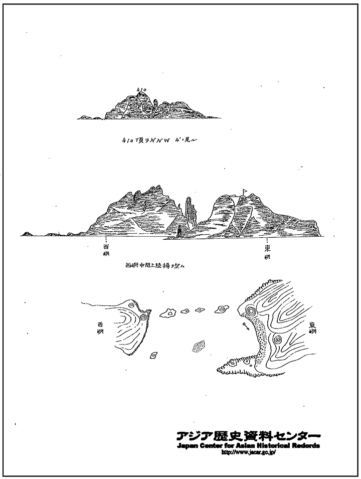
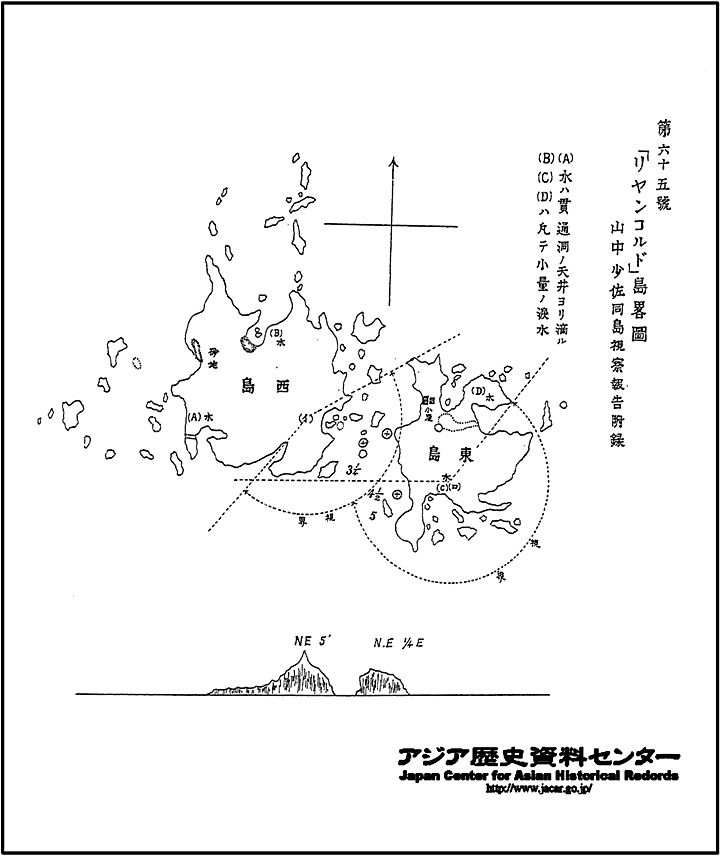
The Tsushima arrived at the Liancourt Island on November 20, and this was the first-ever survey of Takeshima/Tokdo by the Japanese government. The Tsushima’ s captain reported that although there was some topographical difficulty, it was possible to build a structure on the East Islet.
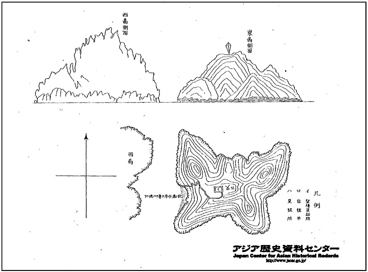
To the left is the map Drawn by Deputy Commander Yamanaka Shibakichi (山中少佐) and followed the format of other Japanese military maps of Korea. This chart showed ideal locations for watchtowers and the location of potential water sources. Also the map included a dotted line which represented the field of view from observation points.
 Although it was determined that Dokdo was suitable for watchtowers and a small base, the Japanese Navy had to wait until June for actual construction. This was because the East Sea is very rough throughout the winter and spring months. Also Dokdo lacked adequate mooring. It was determined special equipment would be needed to haul construction materials up Dokdo’s sheer cliffs on the East Islet.
Another factor that weighed heavily on the construction process was the advancement of Russia’s Baltic Fleet. Until January of 1905 the Japanese military simply weren’t sure the Baltic Fleet would pass through the Tsushima Strait. However, after Port Arthur fell in early 1905 it became an almost certainty that Russia’s Warships would pass through the East Sea (Sea of Japan) in the next few months.
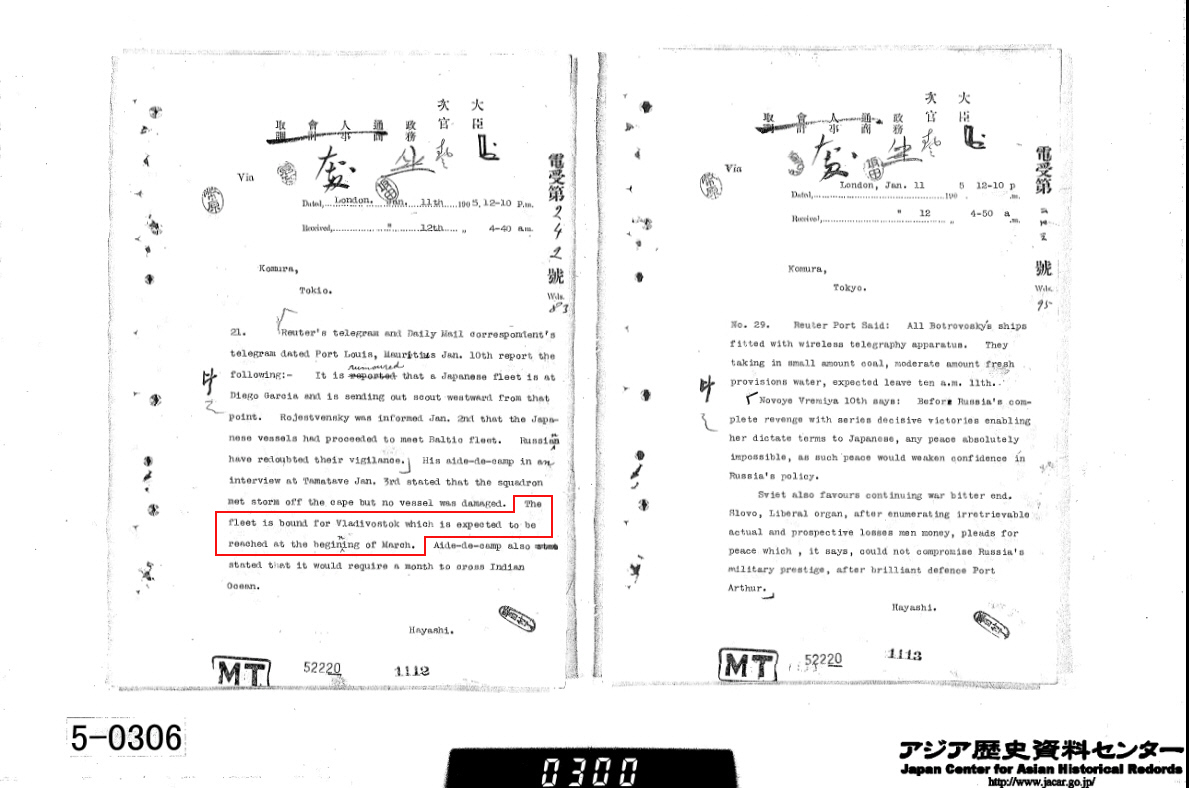
Japanese records from the Russo-Japanese War of 1904~1905 show Komura Jutaro, who was instrumental in processing the application to annex Dokdo received almost daily telegraphs relaying the position of Russia’s Fleet. In early January, Komura Jutaro was sent a telegraph confirming the Baltic Fleet’s destination would be Vladivostok. The Tsushima Strait was the only logical path the Russians could take. (see above right document) Thus, two weeks later the final decision to annex Dokdo was confirmed by a Japanese Cabinet decision on January 28th 1905.