
Old Japanese Maps of Shimane Prefecture Show Oki Islands as Japan’s Territorial Limits
“Just as many Japanese historical records state, Oki Islands were Japan’s Northwest boundary…”
The following maps were gathered from various sources with the intent of making one point. Throughout the ages Japanese national maps prove Dokdo was not considered an inherent part of Japan as their Foreign Ministry now boldly claims. For reference, Oki Island has been boxed and a modern map at the top gives a geographical reference point for the viewer. From these maps, it’s a logical conclusion that for centuries before the annexation of Dokdo in 1905 the Japanese considered Oki Island (隱岐) as the Northwestern boundary of Japan. For higher magnification, each map is clickable.
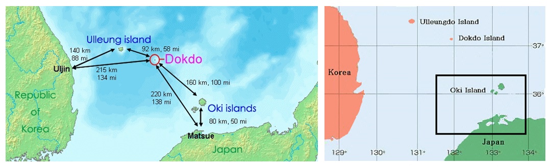
Above Left: A map showing distances to Dokdo from Korean and Japanese nearest islands and landfalls. Above Right: A map showing Japan’s Oki Islands boxed in black. Historically, Japanese considered the Oki Islands (隱岐) as Japan’s Northwestern limit.
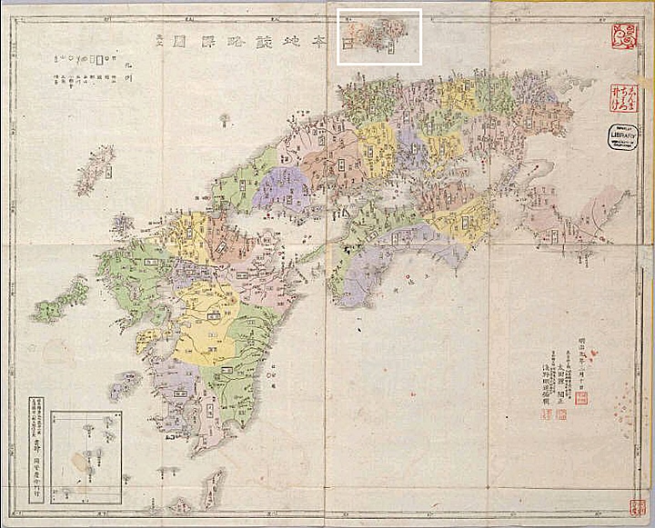
An Introduction: Miyawaki Tsukaku’s 1877 Map of Southern Japan and Shimane Prefecture.
“..A Classic Example of a Japanese Historical Map showing Japan’s western boundary…”
To familiarize the readers of this page with what were the historical limits of Japan, here we have a case study of a typical map from this area. This chart is highly detailed and proves without a doubt, beyond the Oki Islands lie Korean territory. Boxed in blue to the upper right is Oki Island and this map ends only slightly beyond this island group. Again in blue is tiny Minoshima (見島). This shows minor islands belonging to this prefecture were indeed included and thus Dokdo was not part of Shimane prefecture.
The map above was drawn in 1877 and showed the northwestern limits of Japan indicated by the border. Oki Islands (boxed in blue upper right) was the boundary of Japan and Korea’s Dokdo Island was excluded. Tiny minor islands such as Minoshima (blue box upper left) were drawn as part of Japan.
Above left: This close-up portion of the 1877 map confirms the Oki Islands as Japan’s territorial limit. Above right: A larger picture of tiny Minoshima (見島) that lies off of Japan’s West coast confirms tiny minor islands were also drawn on the map. Thus Dokdo Island was not part of Japan.
As a rule, historical Japanese maps of Shimane Prefecture and the Oki Islands omitted Dokdo Island. The maps below confirm this fact.
Above left: An 1876 Japanese map showing the southern portion of Japan. Oki Islands are shown on the border of the map at the top and minor islands are included but Dokdo is not on this chart. Above right: This map dated 1878, shows Shimane Prefecture with the Oki Islands as the westernmost limit of Japan. (click maps)
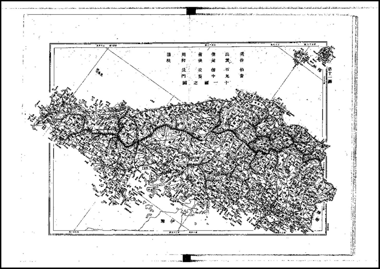
Top left: This Japanese chart, dated 1881 of Shimane and the Oki Islands did not include Dokdo although tiny Minoshima was drawn in at the bottom. Above right: An 1883 colour coded map of Shimane area and the Oki Islands drawn in red as Japan’s limit.
Above maps were drawn in 1890 (left) and 1891 (right) these charts were pages from Japanese national map books. No prefecture maps in these books included Dokdo Island. Note tiny Minoshima (見島) on the lower right of each chart. (click)
Above: Both of the maps above are from the year 1895 and show the Oki Islands group as the limit of Japan. The map on the right included Minoshima (見島) and thus could be said to have included minor islands. Dokdo Island was again not included on either map.
Above left: In 1899 this chart used appended maps to include the distant Oki Islands, however Dokdo Island was still excluded. Above right: An 1897 map of Shimane Prefecture and the Oki Islands without Dokdo.
Above left: Two years before Japan forcibly annexed Dokdo Island Japanese maps did not include the islands. Above right: For years after Japan’s military annexation of Dokdo, Shimane Prefecture maps still did not include Dokdo Island. This was mostly due to Japan’s failure to publicly announce her “incorporation” in 1905.
Above left: In 1908, three years after Japan annexed Dokdo, her maps failed to show the islands. Above right: Even decades after 1905, this map made in 1935 didn’t show Dokdo. At this time Korea was a colony of Japan and the residents of both countries fished the waters around Dokdo Island.
Above pictures: Shockingly, both maps shown here were printed well after Japan seized Dokdo in 1917 (left) and 1941 (right) both maps included the Oki Islands group and used appended charts to include minor outlying islands that were part of Shimane Prefecture, however Dokdo was again excluded.
Japanese Ancient Maps Excluded Dokdo – Takeshima Part IV – The Only Possible Conclusion
“Japan’s MOFA’s claims are false. Dokdo was never an inherent part of Japan…”
When studying historical maps to determine past territorial perceptions, one must first collect as many charts as possible of the region in question made by the nation that created them. From there, these maps must be examined and compared to find a dominant trend. With this in mind, there can be no other conclusion that Japan excluded Dokdo Island from her land throughout history. The islets were never part of Japan.
This page is last of a four-page series. If the reader reads and observes the dozens of charts found here and on the subsequent pages, it’s possible to conclude the following: Not only did Japan exclude Dokdo from her territory, she frequently labeled and drew the islets as Korean. Thus Japan’s MOFA claims of historical title to Dokdo are simply wrong. Dokdo island is not, and was not an inherent part of Japan.