Japanese Territorial Perceptions in the 19th Century Shown Through Maps
The Argonaut Island Confusion Explained
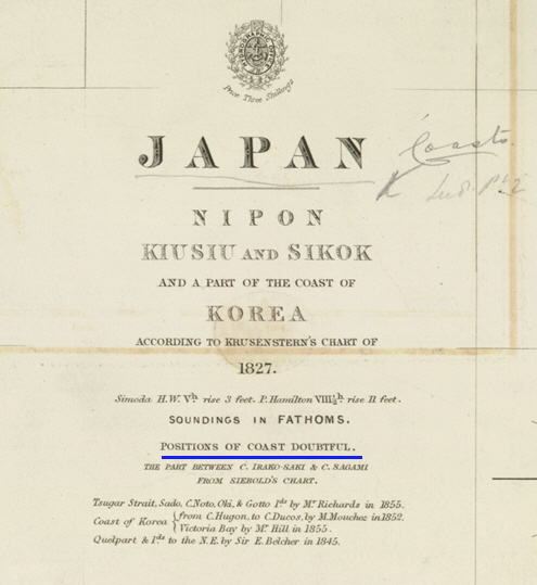
Over the years Korea researchers have continually presented Japanese documents and maps (
link 1 ) (
link 2 ) that show Ulluengdo (Takeshima Island 竹島) and Dokdo (Matsushima Island 松島) as part of Chosun territory. Two examples of these records would be the 1870 Report on Chosun (
link ) and the 1877 Dajokan’s Report on Ulleungdo and Other Island (
link ) The identity of these islands is heavily disputed by Korean and Japanese scholars. This page was created to eliminate confusion by using numerous Japanese maps of the 19th Century. But first a couple maps to help readers familiarize themselves with the Ulleungdo Dokdo region.
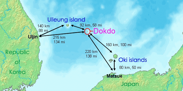
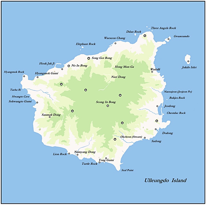
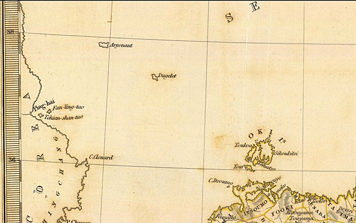
Above left: An overall map of the Ulleungdo – Dokdo region showing distances to nearest Japanese and Korean landfalls. Above right: A map of Korea’s Ulleungdo Island.
Japanese Historical Maps of the East Sea (Sea of Japan) Prior to 1840
Early Japanese Maps of Ulleungdo (Takeshima – 竹島) and Dokdo (Matsushima – 松島)
The first Japanese maps of Takeshima (Ulleungdo) and Matsushima (Dokdo) showed the islands labelled as 竹島 (Takeshima-Ulleungdo) and 松島 (Matsushima-Dokdo). The positions of the islands were slightly easterly of their real locations and their forms were rarely accurate. The two islands were never far apart and they were always of the same colour as a pair or sister islands.
The earliest known Japanese map of Ulleungdo and Dokdo Islands are dated during the 1770s and drawn by Japanese cartographer Nagakugo Sekisui. The shape of both islands, as with most Japanese maps shows the islands as vague oval forms. Nagakubo Sekisui’s chart was copied in numerous editions with different colourations for decades and even after his death. His map could be said to be the bechmark of Japanese maps of Japan and the East Sea (Sea of Japan). It’s safe to say by the end of the 18th Century the Japanese had a fair knowledge of the East Sea (Sea of Japan). Also, please take note of the Kanji quote “見高麗如自雲州望隠州” drawn next to Ulleungdo and Dokdo this text was a historical reference explaining Korea was visible from this region. ( see link )
Nagakubo Sekisui’s 1779 Chart of Japan and the East Sea (Sea of Japan)
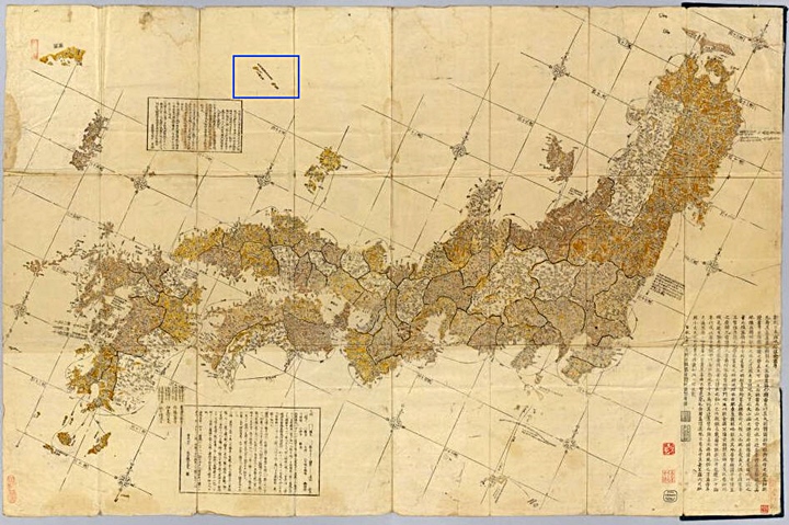

Above left: An overall image of Nagakubo Sekisui’s 1779 map which shows Ulleungdo (竹島) and Dokdo (松島). Above right: A closeup of Ulleungdo and Dokdo. Note Ulleungdo’s incorrect cashew shape and Dokdo’s incorrect one-island oval form.
A 1793 copy of Nagakubo Sekisui’s Map of Japan
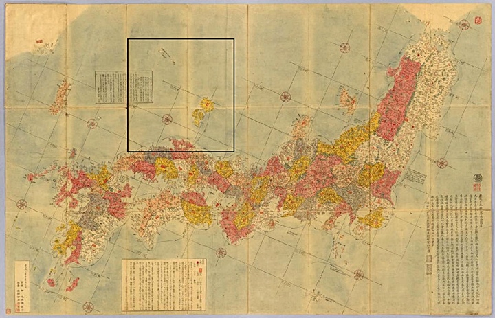
Above left: An overall image of a 1793 copy of Nagakubo Sekisui’s 1779 map which shows Ulleungdo (竹島) and Dokdo (松島). This map was copied by Japanese cartographer, engraver Inoue Jihe. Above right: A closeup of Ulleungdo and Dokdo Island. Note Ulleungdo’s incorrect cashew shape was copied from the original chart. Also Dokdo’s shape is incorrect but identical to its previous version.
An 1840 copy of Nagakubo Sekisui’s Map of Japan
Above left: An overall image of a later copy of Nagakubo Sekisui’s 1779 map which shows Ulleungdo (竹島) and Dokdo (松島). This map was copied by Japanese cartographer, engraver Inoue Jihe. Above right: A closeup of Ulleungdo and Dokdo Island. Note 60 years later, Ulleungdo’s incorrect cashew shape was copied from the original chart. Also Dokdo’s shape is also incorrect but an exact copy of early verions of Nagakubo Sekisui’s.
Some Observations About Japanese Cartography Around the 18th Century
These standard Japanse maps of the day tell us some things about the territorial perceptions of Japanese cartographers of the late 18th and early 19th Centuries.
First these map makers had only a general idea of how far away Ulleungdo and Dokdo were from Japan and Korea. It’s quite probable Nagakubo Sekisui referenced Saito Hosen’s 1667 Report on Oki ( see link ) and then roughly drew the distance of the islets around 2 and half travel days away from Oki Islands. In fact Korea is much closer to Ulleungdo than the Oki Islands but does not appear on the map.
Therefore the Japanese maps show Ulleungdo and Dokdo much too far East. Also notice how Ulleungdo and Dokdo are drawn beyond the lines of latitude and longitude on these charts. These island are often left uncolored when the nearest Japanese Oki Islets are bright yellow or pink. This would mean both islands were not thought to be part of Japan.
“Japanese Cartographers Traced Island Forms and Locations, Even When Incorrect…”
Another important observation tell us a little about cartographers of this era. Nagakubo Sekisui drew the forms of Ulleungdo and Dokdo incorrectly. Ulleungdo is drawn as a cashew shaped oval when in reality the island is almost triangular. Dokdo island is depicted as an oval shape when Dokdo really consists of two islets and numerous surrounding rocks. ( see above map on right ) Despite the glaring obvious errors in island forms and locations numerous Japanese cartographers and engravers would copy these charts to the letter for at least sixty years with no alterations. This is an important consideration when we study maps made in the following decades. In reality mapmakers of this era were rarely original geographers but rather artists, engravers and printers.
18th Century Europeans Double-Map Korea’s Ulleungdo Island
The mapping errors created by the Europeans resulted from two different explorers from two different times and nations, These first mistakes originated from Europeans incorrectly charting the island of Ulleungdo in two different geographic positions and names.
Calaup de la Perouse ‘Discovers’ Ulleungdo Island
In the year 1787, French navigator Calaup de la Perouse ‘discovered’ Ulleungdo and named it Dagelet. He correctly mapped the island at it’s proper location of 37.26′ latitude and 130.56′ longitude. Perouse drew Ulleungdo quite accurately and even included features such as Ulleungdo’s surrounding rocks. Perouse also went into detail about Koreans he saw on Ulleungdo (Dagelet) You can read about his experience on Ulleungdo here (
link )
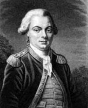
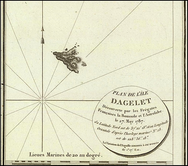
Above left: An image of French explorer Calaup de la Perouse who found and mapped Ulleungdo Island in 1787. Above right: Perouse’s map of Chosuns Ulleungdo (note adjacent rocks on map)
Englishman James Colnett Also Finds But Incorrectly Maps Ulleungdo Island
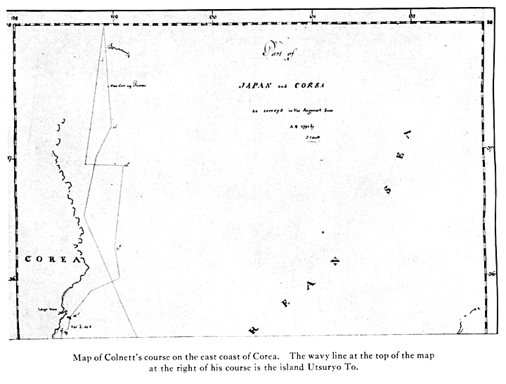
Later, in 1789 British explorer James Colnett also found Ulleungdo and named it Argonaut Island. however this island was mapped incorrectly. Colnett assigned the location 37.32′ latitude and 129.50 longitude.
To the right is James Colnett’s map of the East Sea (Sea of Japan) on his voyage chart Ulleungdo is drawn as a crude set of wavy lines. During this voyage Colnett’s ship lost her rudder somewhere South of Chosun’s Ulleungdo Island.
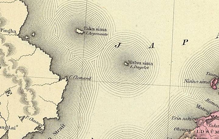
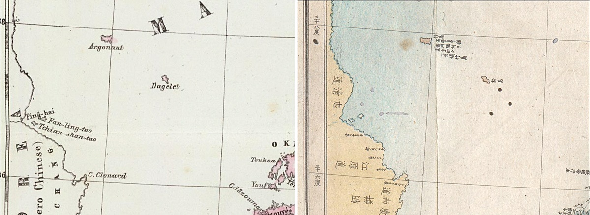
Because two different locations and names had been given to Ulleungdo, two islands (both Ulleungdo) were drawn on European maps of the East Sea (Sea of Japan) For a brief period thereafter Argonaut Island, was included on European maps. Later, Argonaut would be depicted as the real Ulleungdo (竹島~Takeshima) and Dagelet would represent Dokdo (松島~Matsushima). (click map)
European Maps Showing Argonaut and Dagelet Islands, Before and After -1840
After the double-mapping of Chosun’s Ulleungdo Europeans would continue to show two islands in the East Sea (Sea of Japan) called Argonaut and Dagelet. Japanese maps would also show two islands called Takeshima (Ulleungdo) and Matsushima (Dokdo) This would lead to the assumption that Argonaut Island was Ulleungdo (竹島-Takeshima) and that Dagelet was Dokdo (松島-Matsushima) by European, Phillipp Franz Siebold as shown below.
Above left: An overall view of John Thomson’s 1815 map of Korea and Japan. This chart shows Argonaut (wrongly mapped Ulleungdo) and Dagelet (correct Ulleungdo) Note the islands’ forms and location. Above right: A close-up of Argonaut and Dagelet islands.

Above left: An overall view of J.C. Walker’s 1835 map of Korea and Japan. This chart also shows Argonaut (wrongly mapped Ulleungdo) and Dagelet (correct Ulleungdo) Note the islands’ forms and location similar to the map above and identical to the other European charts below. Above right: A close-up of Argonaut and Dagelet islands.

Above left: An overall view of Coulton’s 1856 map of Korea and Japan. This chart shows Argonaut labelled as Takeshima (Ulleungdo) and Dagelet now named Matsushima (Dokdo) This was obviously from Siebold’s error. Note the islands’ forms and locations are the same as J.C. Walker’s 1835 map. Above right: A close-up of Argonaut and Dagelet islands.
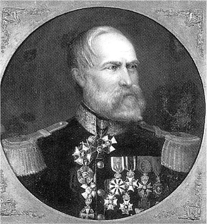
Phillipp Franz Siebold Assigns Japanese Names to Argonaut and Dagelet in 1840
Philipp Franz Balthasar von Siebold (February 17, 1796 in Würzburg – October 18, 1866 in Munich) was a German physician who arrived in Japan on August 11, 1823. He emerged as the first European to teach Western medicine in Japan. Sielbold obtained from the court astronomer Takahashi Kageyasu several detailed maps of Japan and Korea (written by Ino Tadataka).
 As mentioned, when comparing Japanese and Western maps Siebold saw two islands in the East Sea (Sea of Japan) on both charts. From there he made the only natural conclusion that Argonaut Island was Takeshima (Ulleungdo) and Dagelet was Matsushima (Dokdo) and labeled them accordingly. In turn, Japanese cartographers would reference these western maps and copy the incorrect westerly locations of the islands unaware of the error.
Thus, Takeshima (Ulleungdo) and Matsushima (Dokdo) would be drawn in more Westerly locations with Ulleungdo-(竹島) being mapped at 129.3 degrees and Dokdo (松島) at 130.56 degrees. However, it’s quite apparent the Japan had no idea of the origins of this mistake and simply followed their age old practice of mapping two islands in the East Sea named Takeshima and Matsushima (as we will see below) and simply copied Siebold’s positions. This mapping procedure would continue for decades even after the positional error was discovered.
Phillipp Franz Siebold’s 1840 Map of Japan and the East Sea (Sea of Japan)
Argonaut Island Labeled as Takeshima (Ulleungdo) and Dagelet as Matsushima (Dokdo)

Above left: An overall view of Siebold’s 1840 map. Above right: This closeup of Argonaut Island and Dagelet shows how Sielbold wrote Takeshima (Japanese for Ulleungdo) and Matsushima (Japanese for Dokdo) next the islands. Japanese cartographers would later copy the islands’ names, shapes and locations onto their own charts.
Japan Names Argonaut as Takeshima (Ulleungdo) and Dagelet as Matsushima (Dokdo)
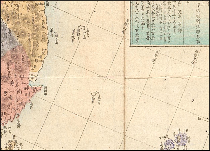
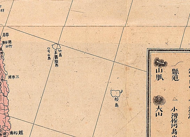
A comparison of European and Japanese Maps: B. Marzollo (1847) ~ Uchida Shinsei (1872)
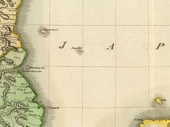
To illustrate how Japanese map makers copied their western counterparts, below are two standard 19th Century European and Japanese maps of Japan. The first map by Bendetto Marzollo shows Argonaut Island labeled as “Takeshima” and Dagelet as “Matsushima” This was not unusual as J.C. Walker’s 1835 map above shows ( map image 1. ) and as Coulton’s 1856 chart ( map image 2. ). Take note as to the incorrect forms and locations of the islands.
From these maps Japanese cartographers would apply the Kanji equivalent “竹島” for Takeshima (Ulleungdo) and “松島” for Matsushima (Dokdo). On the Japanese map by Uchida Shinsei we can also see the characters “見高麗如自雲州望隠州” next to Ulleungdo which proves beyond any doubt that the Westerly island was Ulleungdo. See early Japanese maps above. The logical conclusion we can draw from these maps is that Japanese cartographers located Ulleungdo (Takeshima) and Dokdo (Matsushima) in more westerly locations from the logical assumption Argonuaut was Ulleungdo and Dagelet was Dokdo.
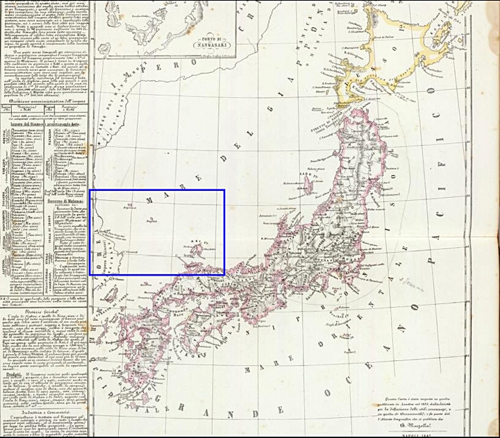
On the left is an 1847 European Map by B. Marzollo showing Argonaut Island and Dagelet. To the right is a Japanese chart which assigned the name Takeshima (竹島 ~ Ulleungdo) to Argonaut and Matsushima (松島 ~ Dokdo) to Dagelet. The Kanji Characters “見高麗如自雲州望隠州” (see Japanese charts above) next to Takeshima (竹島) confirm this island was considered Ulleungdo by the Japanese mapmaker Uchida Shinsei
Siebold’s Error is Discovered and Charts are Corrected, Early 1850s
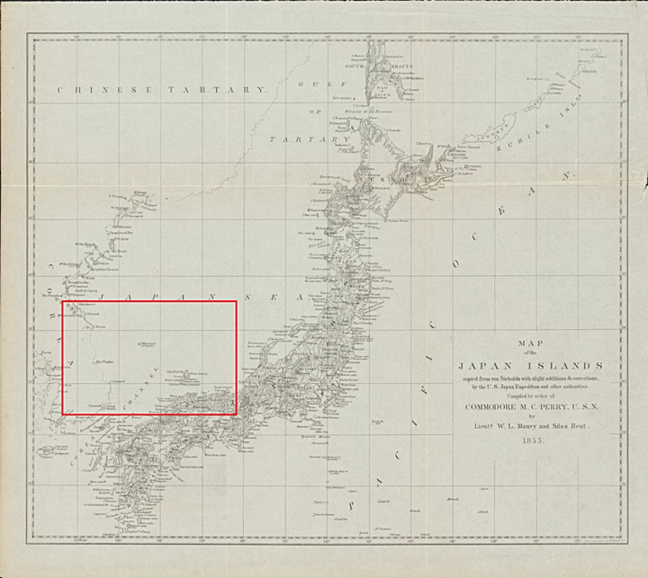
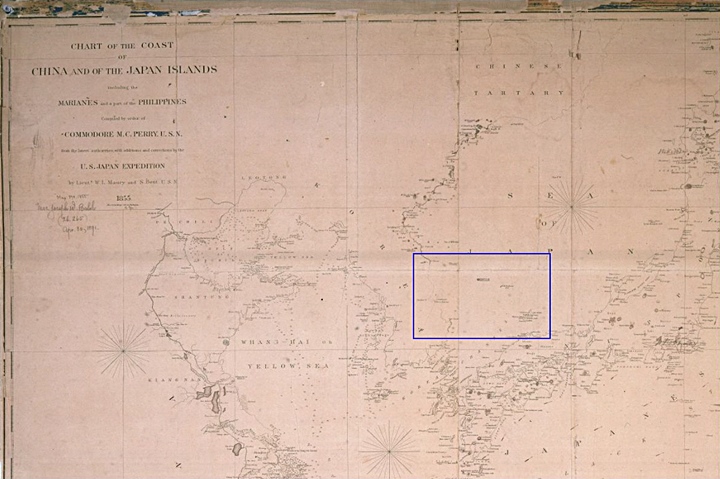
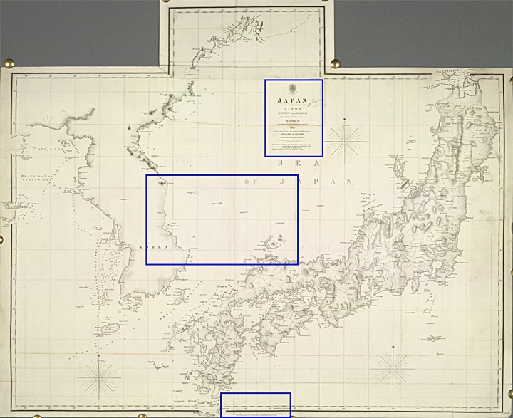
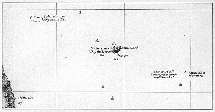
An 1855 U.S. Navy Map of Korea and Japan By Lieuts, W.L. Maury and Silas Bent
Twice during the early 1850s, (1852-1854) the U.S. Navy under Matthew C. Perry, conducted expedtions to Japan. The two maps below are the result of these voyages. As the legend states they are in part based on Phillipp Franz Siebold’s 1840 Map of Japan and the East Sea. Notice that Argonaut Island has been deleted from this chart and Liancourt Rocks (Dokdo) had yet to be added. Also take note, the East Coast of Korea is drawn in dotted lines meaning the features of Korea’s coast were unconfirmed or unclear. Shortly later, Argonaut Island would also be drawn in dashed lines indicating the island’s position and existence were doubtful. (see below)
CONTENT GOES HERE
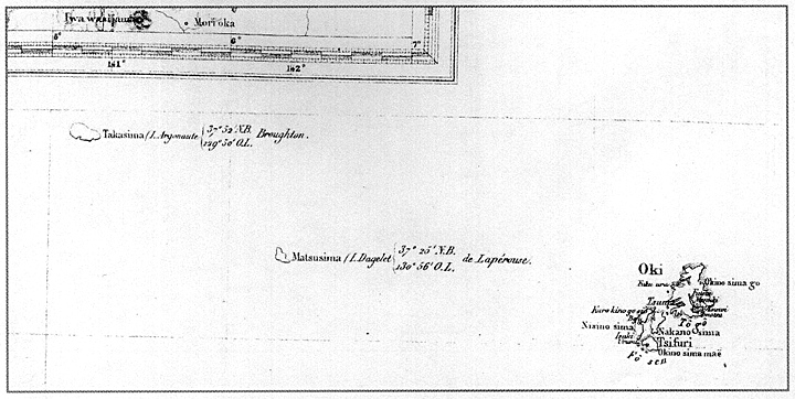
Charts Showing Three Islands in the East Sea (Sea of Japan)
Western Nations “Discover” Dokdo in 1849 – Three Islands in the East Sea (Sea of Japan)
In 1849, a French whaler Liancourt reported the discovery of an island and Dokdo began to show up on maps from Europe. Due to the double-mapping of Ulleungdo, three islands appeared on some maps. Dokdo was labelled as “Liancourt Rocks” A few years later the British warship Hornet found Dokdo and named it “Hornet Rocks”.
Just three years later, in 1852 the French corvette Capricieuse twice passed over Colnette’s Argonaut location and could not find any land. In June of 1859 Britains HMS Actoeon also passed over the position given to Argonaut and saw nothing for a radius of at least five miles. The same year a Russian gunboat also visited Argonaut’s supposed position and determined no island was present there. From these surveys it would become common knowledge amongst the European nations that Argonaut Island did not exist during the 1850s.
From the UK’s Hydrographic Office Admialty in 1864 a quote summarizes European sailors’ knowledge of Argonaut Island “This island has been searched for by both French and Russian ships of war, but has not been found: whalers also ignore its existence; it may therefore with confidence be expunged from the charts. It’s discoverers, probably owing to current, were much out their reckoning, and sighting Dagelet (Ulleungdo) re-named it.”
An 1855 American Map of Korea and Japan
As the charts title states, the map below was published in 1855 by the order of U.S. Commodore M.C. Perry of the U.S. Navy. The map was based on the most up-to-date geographic information the Americans had at the time. Here we see the name “H.M.S. Hornet ” was used for Dokdo, suggesting it was influenced by a British map. Most importantly Argonaut Island is marked as “not existing”
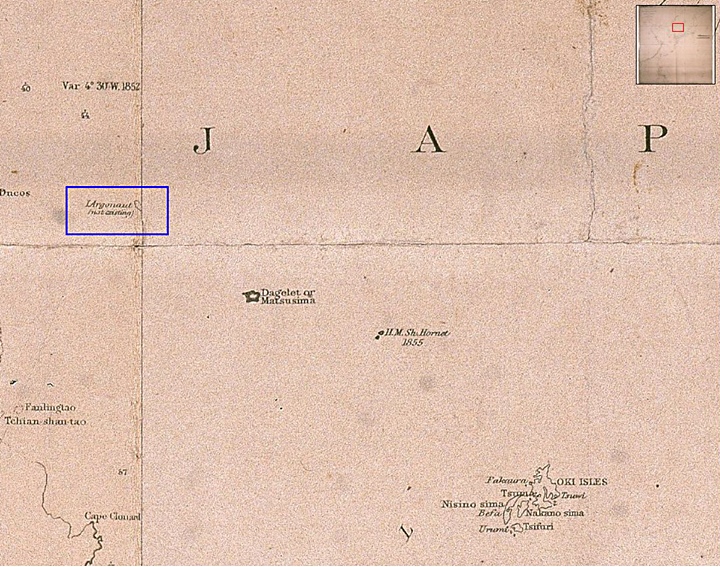
Above left: An overall view of an 1855 U.S. Naval chart of Asia’s waters. Above right: A close-up of the East Sea (Sea of Japan) shows Argonaut Island marked as not existing.
An 1855 European Map of Korea and Japan by Heine
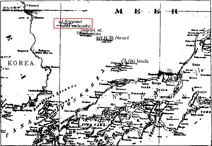
To the right is a European chart showing Korea’s and Japan’s adjacent waters. Again three islands are shown in the East Sea (Sea of Japan). Boxed in red is Argonaut Island. Again, on this map the former Argonaut Island island is marked as “nicht vorhanden” or non-existent.
Japanese cartographers would copy many of these European charts. Most of Japan’s maps especially military (naval) were copies of British and Russian charts. Thus, it is a fair statement to say, whatever georgraphical knowledge Europeans had of the Ulleungdo – Dokdo region, so did the Japanese. Also, because Japanese translated the foreign names of islands ports etc., into Japanese, we know they must have been cognizant of the consistent “Argonaut non-existent” written there.
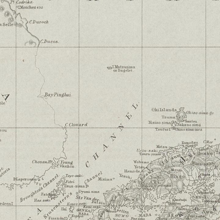
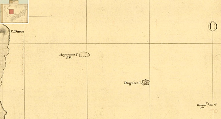
An 1855 British Naval Map of Korea and Japan From Mouchez’s 1852 Map.
The map to the right was drawn under the supervision of the English Admiralty in 1855. It once again confirms western nations realized Argonaut Island was non-existent.
As with the Korean coastline, Argonaut Island’s previous location was drawn in a series of dashed lines. Reading the map’s legend it explains positions on the Korean coast were “doubtful”. Similarly Argonaut Island is marked with “P.D.”
Like many charts, the 1855 British Naval map has a legend detailing the source of the geographic information. It appears Korea’s East coast’s data was from an 1852 survey. From this, we can say Europeans had accurate knowledge about Argonaut Island starting around the early 1850s. Reading the maps’ legends illustrates how quickly Western nations acquired geographic information from each other.
CONTENT GOES HERE
A Comparison of Mid-19th Century British and Japanese Naval Charts
“19th Century Europeans and Japanese Openly Exchanged and Translated Geographical Information…”
The two maps below are as the title suggest naval maps from both the Japanese and British navies. The first two images show the overall chart and on the right is the map’s legend. This again explains that Argonaut or Takeshima Island’s position is “doubtful” and not surprisingly it is outlined in a dashed line. Accordingly the Japanese chart has Takeshima (竹島) in a dashed line. What’s also important is that the Japanese cartographer translated various features on the map such as Ulleungdo’s surrounding rocks. Also, we can see how the depths of the water were recorded exactly the same by the Japanese in the correct locations. From this we know the Japanese were as knowledgeable about the geographical situation in the region as the Europeans.

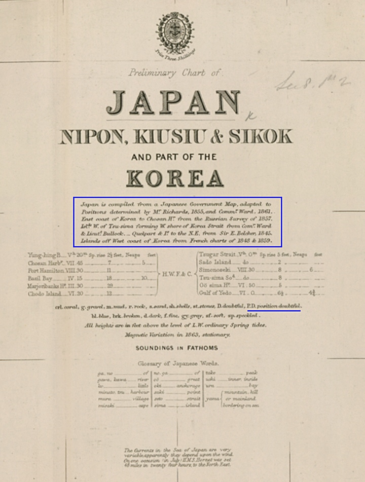
Above left: An overall image of the 1863 British Naval Map. Above right: A closeup of the chart’s legend explaining that Argonaut aka Takeshima were “doubtful” of this chart.

The maps above confirm how Japanese cartographers copied European charts to the letter. Notice how Takeshima (竹島) is also drawn in a dashed line illustrating the island’s existence was “doubtful” Also, take note as how the Japanese cartographer translated various features on the chart and copied the ocean depths.
The Bizarre Interpretation of Japanese maps by Takeshima Lobbyists
“Was Takeshima Island (竹島) Really a “Phantom Island” on 19th Century Japanese Maps as Takeshima Lobbyists Insist…?”

During the 19th Century Japanese maps showed Takeshima and Matsushima as Chosun territory. As Japanese cartographers copied Western charts, these charts showed the classic positional errors created by the Europeans. Takeshima was located in Argonaut’s position and Matsushima was in the original Ulleungdo location. However, what were the Japanese mapmakers thinking? Did they know the Europeans had mapped a non-existent island? (Argonaut)
Japanese Takeshima lobbyists theorize the following. On Japanese maps showing Seibold’s locations Japanese cartographers knowingly mapped Argonaut Island as a fictitious ghost island called Takeshima and included Ulleungdo Island labelled as Matsushima. They also assert Japanese mapmakers then omitted the former Matsushima (Dokdo).
The map to the right is a classic example of how some Japanese have distorted the facts about Japanese mapping errors of the 19th Century. This map, from a pro-Takeshima website, claims the Japanese cartographer drew “fabled Ulleungdo” on the East, the real Ulleungdo to the West and then omitted Matsushima (Dokdo). Is this true?
If we ignore the misleading flashy effects, we can see three rows of Kanji characters next to the western island. These characters read 竹島 (Takeshima) 鬱陵島 (Ulleungdo) and 于山 (Usando). This confirms the identity of this island as Ulleungdo. The island to the East labeled 松島 is thus Matsushima of old or Dokdo Island. This was quite common and below are some classic examples of these charts.
“Argonaut Island” Confirmed as Ulleungdo on Many Japanese Maps.
The Takeshima (竹島) in Argonaut’s location is Ulleungdo, thus Matsushima (松島) was Dokdo
CONTENT GOES HERE
CONTENT GOES HERE

CONTENT GOES HERE
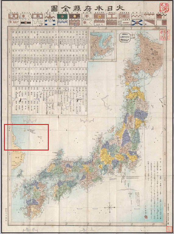
Some Japanese Meiji-Era Maps Showing Dokdo (Matsushima 松島) as Korean
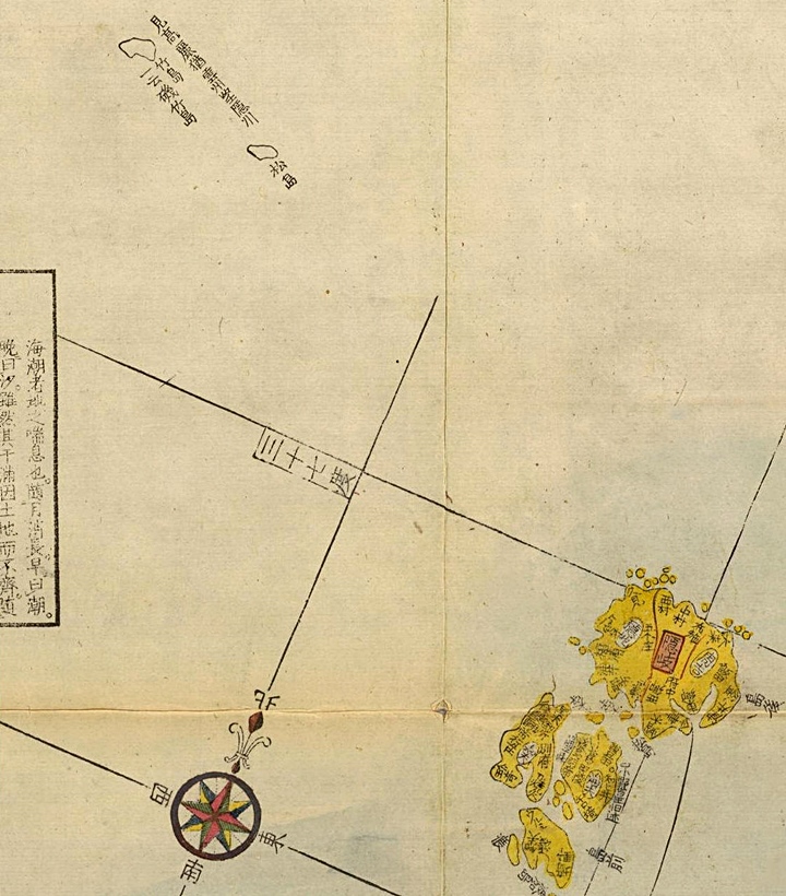
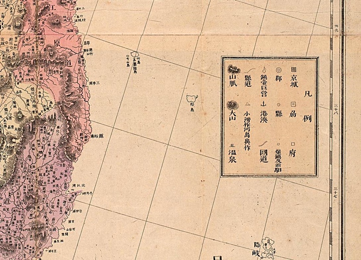
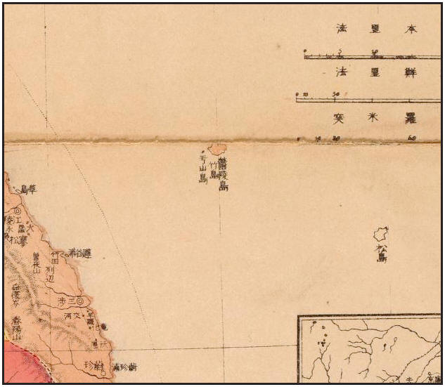
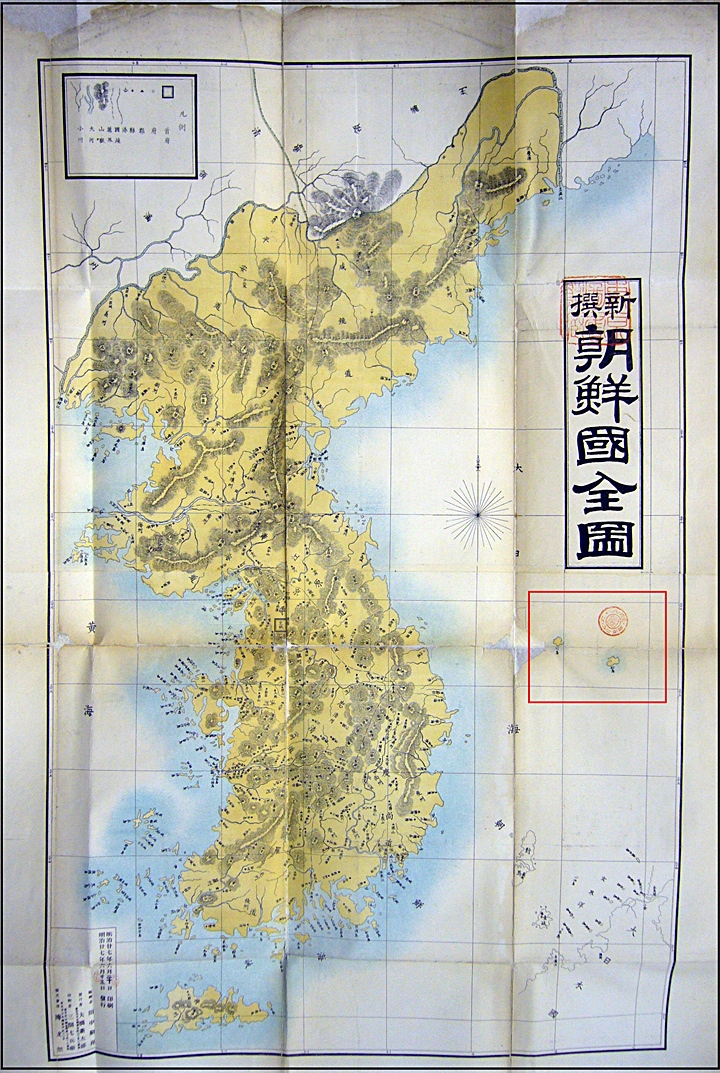
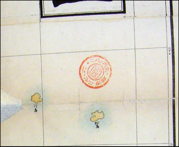
When Japanese cartographers referenced Siebold’s map they wrote their names for Ulleungdo (Takeshima 竹島) and Dokdo (Matsushima 松島) rather than Argonaut and Dagelet. The map below was drawn by Japan’s Mori Kinseki in 1877 and it shows the same positional errors of this time. We can observe Ulleungdo (竹島) and Dokdo (松島) belonged to Korea. In addition the islands are color-coded the same as Korea’s Kangwan Province. The top image includes all of the map and boxed in blue was an appended map of Chosun (Korea) The two lower maps indentify clearly Ulleungdo and Dokdo labelled and named in the same fashion the Japanese had for 150 years
An 1877 Japanese Map of Korea by Mori Kinseki

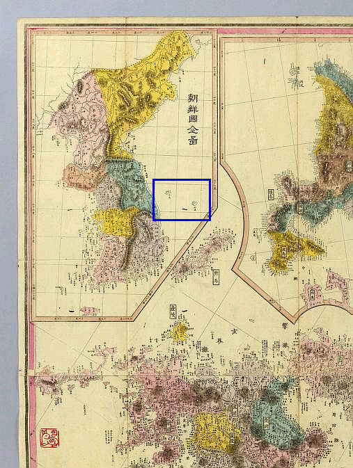
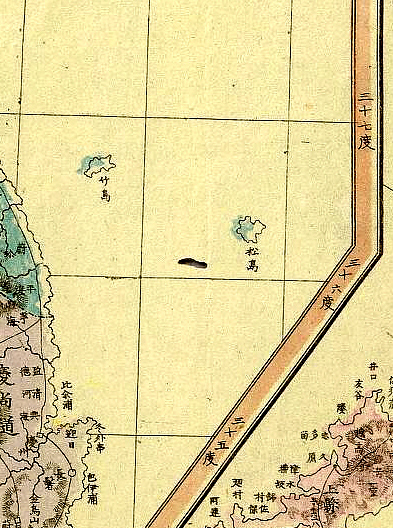
Above images: The close-up pictures show Ulleungdo and Dokdo colored the same as Korea’s Gangwan Province and separated from Japan by the Korean map’s border.
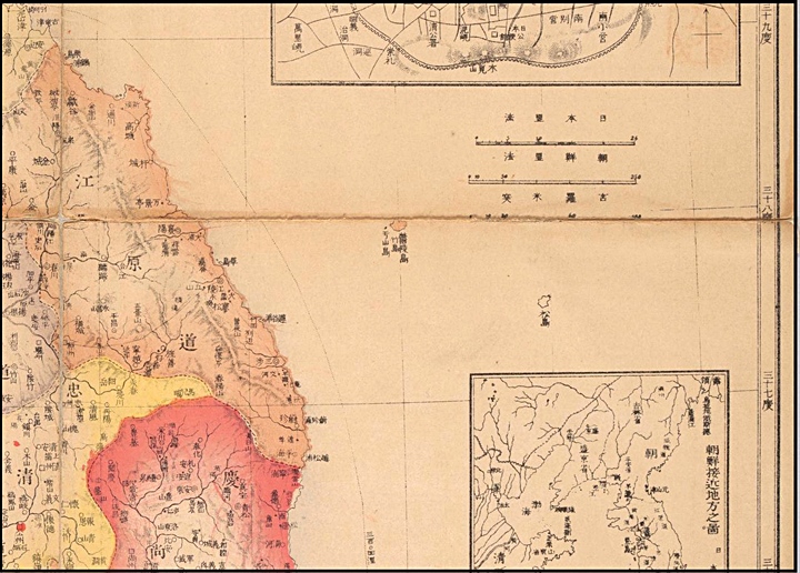
An 1894 Japanese Map of Korea
Abve left: An overall image of the 1894 map showing Ulleungdo (Takeshima – 竹島) and Dokdo (Matsushima 松島) Above right: An extreme close-up showing Ulleungdo (Takeshima – 竹島) and Dokdo (Matsushima 松島) click maps.
A 1903 Japanese Map of Asia Showing Korea’s and Japan’s National Boundaries
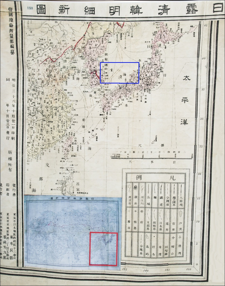
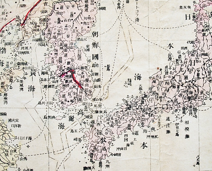
Above left: An overall image of the entire 1903 Japanese Map, with Ulleungdo and Dokdo boxed in blue. Above right: A close-up of the Ulleungdo (竹島) and Dokdo (松島) region. Note the boundary of Japan (日本界) drawn East of Dokdo putting the islets within Korea’s territory. (朝鮮界)
