
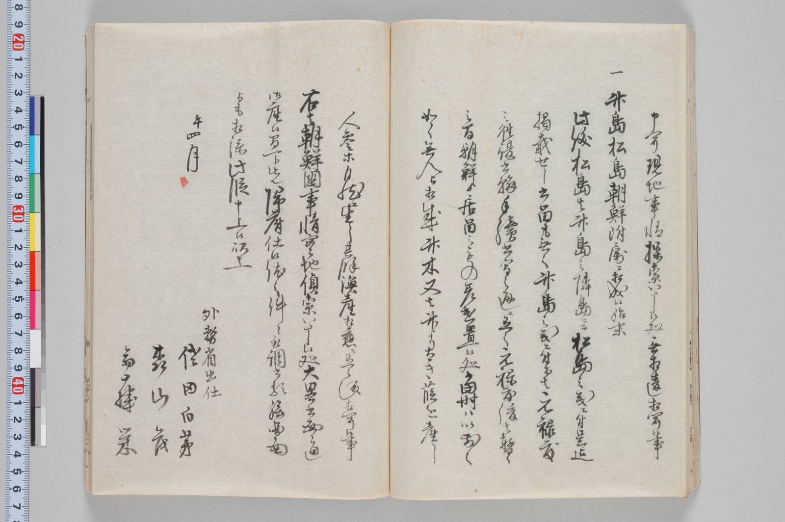
 The following page is yet another record proving the Japanese Government (Meiji) considered Dokdo Island as part of Chosun (Korea). Dokdo Island is sometimes called Liancourt Rocks by western nations and Takeshima by Japan. Most websites regarding the Dokdo dispute include the 1870 Secret Mission Report about how Ulleungdo and Dokdo became Chosun’s possessions. However, most of them post only the relevant passage shown below. But the report was more than just proof the Ulleungdo and Dokdo were the possessions of Chosun. This secret report and its motivation for being instigated, gives us an inside look into the real intentions of the Japanese government during Chosun’s Opening of Ports Era.
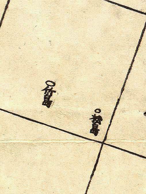
“…竹島松島朝鮮附屬 “How Takeshima (Ulleungdo) and Matsushima (Dokdo) became Korean Possessions…”
“…Matsushima (Dokdo) is a neighbor island of Takeshima (Ulleungdo) and there is no document on file by the shogunate concerning this (these) island(s). 2. The island of Takeshima (Ulleungdo) was settled by the Korean people after the 1690s (During the reign of King Sukjong) but it now has become uninhabited…..”
Sada Hokubo wrote:
“…If Imperial Japan passes this great opportunity to the foreigners, we will lose our lips (ie Korea) and then our teeth will surely suffer from the cold. Korea is a gold mine and wheat and rice are abundant. With one sweep we can mobilize the manpower, the mineral resources and the grain in Korea and use them in Hokkaido…..”
This document foreshadows the Japanese attack on Kangwha Island on September 20, 1875. The intrusion would set the wheels in motion for a series of unfair treaties and the gradual occupation of Korea.
The only issue of contention is the identity of Matsushima (松島). Japanese lobbyists insist the Matsushima in this record is a different island. The 1870 report mentions that Matsushima was a neighbour island (隣島) of Ulleungdo. Was there another island near Ulleungdo refered to Matsushima (松島)? When we cite maps of the era, the Japanese “interpretation” of this important document can be dismissed as false.
Were the Japanese talking about a different Matsushima (松島) in this report, or did they continue to use the same name for Dokdo Island as they had for 200 years prior? The Japanese maps of the East Sea (Sea of Japan) and Ulleungdo, clarify this disagreement.
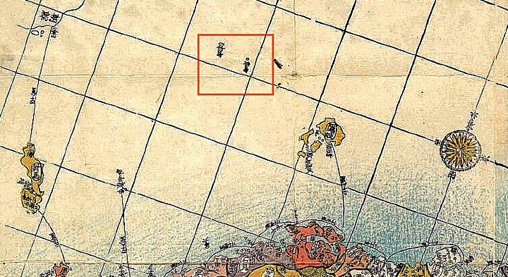
 The map to the right of this text was drawn by Kashihara Yoshinaga in 1876 and is typical of Japanese maps of the East Sea (Sea of Japan) showing both Ulleungdo (竹島) and Dokdo (松島). As with all Japanese national maps, the shape of Dokdo (松島) is incorrect. No Japanese maps, aside from the private charts drawn by the Murakawa or Oya fishing clans depicted Dokdo in its correct two islet form, but rather vaguely traced an outline based on preceding maps.
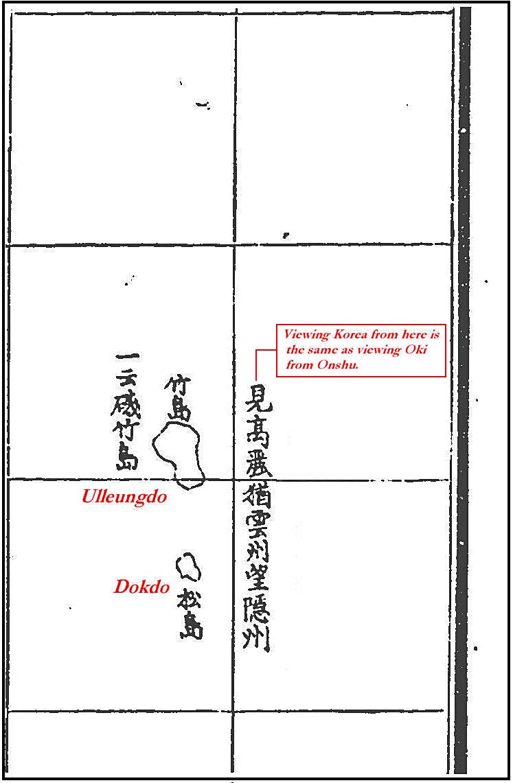
The position of Ulleungdo is more westerly due to the influence of European charts. Most importantly Ulleungdo is labelled as “日本 (Japanese) name Takeshima (竹島) and 朝鮮 (Korean) name Ulleungdo…”No other islands exist in the East Sea on this map. Confirming the identity of Matsushima – 松島 as Dokdo Island. An abbreviated form of Saito Hosen’s “…Viewing Korea from here is similar to viewing Oki from Onshu…” (見高麗如雲州望-州) is drawn next to Matsushima – 松島 (Dokdo Island) as had been the case for over a century prior. (click picture for larger image)
The maps included with this report show both Ulleungdo’s neighbouring rocks and islets as well as a larger map of the East Sea (Sea of Japan) To further confirm the islands’ identity Saito Hosen’s 1667 quote “見高麗如雲州望-州” is drawn next to Ulleungdo and Dokdo. Take notice that this map is strangely oriented with West to the top of the page and East at the bottom. Thus, South and North are drawn left to right.
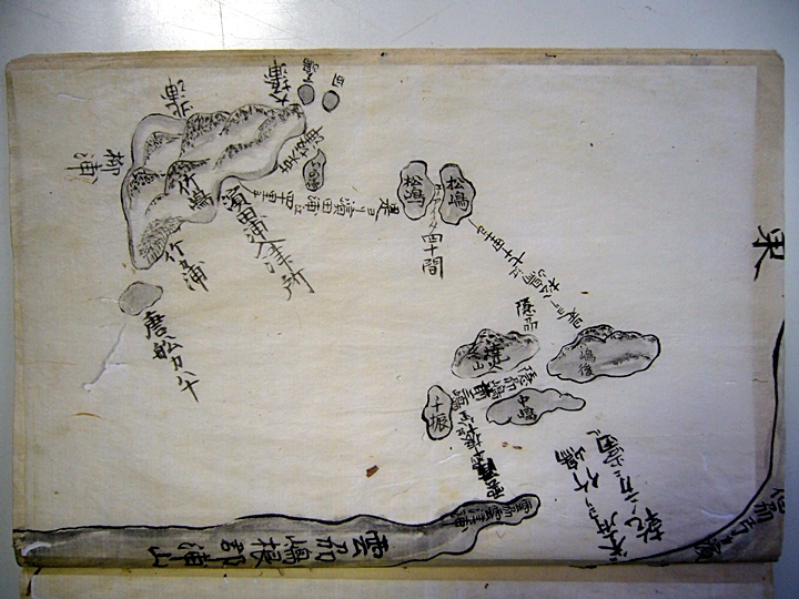
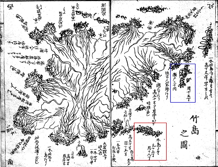 As mentioned, included within the report on Ulleungdo was a highly detailed map of Ulleungdo itself. This map of Ulleungdo can be seen to the left. The island is drawn askew with North and South being positioned diagonally. Notice how Ulleungdo is labelled as Takeshima (竹島) on the bottom right.
Looking closely, all of Ulleungdo’s surrounding rocks and minor islets are included. Some rocks such as Chotdae Rock, Three Angels Rocks, Bukjeo Rock and Seal Point can all be located on this detailed map. However, nowhere within this map is there any adjacent islet named Matsushima. Only on the overall map of the East Sea is there an island referred to as Matsushima. This of course, would be Dokdo Island.
Pooling all of the related data, how some Japanese can maintain the position Matsushima was different island other than Dokdo remains a mystery. There doesn’t seem to be one piece of historical data to support this theory. More than likely this theory is an excuse to disregard a critical piece of historical data that essentially amounts to a “stake in the heart” for Japan’s MOFA’s claims of historical ownership over Dokdo Island.
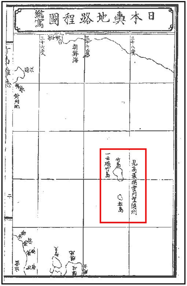
A 19th Century Japanese Map of Ulleungdo, Dokdo and Japan’s West Coast
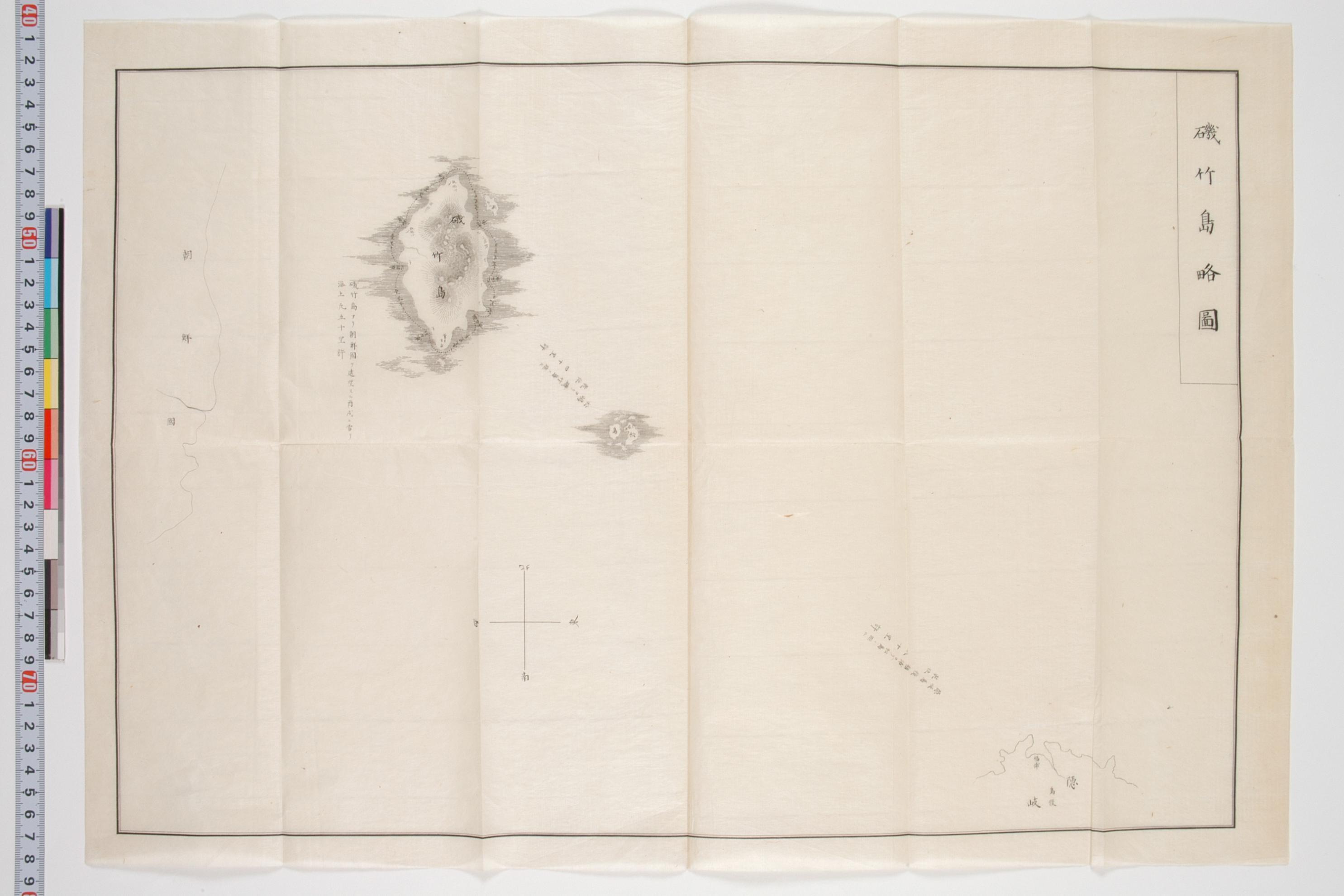
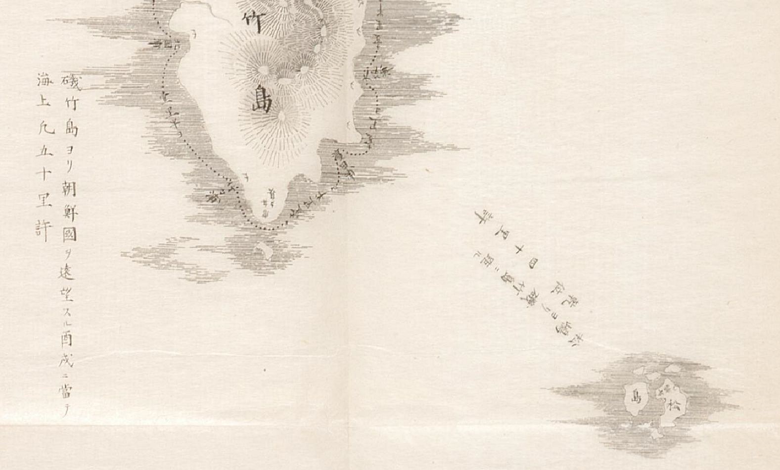
 The map to follow is important for a few reasons. First it records the illicit voyages of Japanese fishermen onto Chosun land originating from Yonago City. Ulleungdo and Dokdo are drawn in correct form and name. This chart correctly depicts Dokdo Island as two islets en route to Korea’s Ulleungdo Island.
Also this map enforces the fact that the Japanese perceived no extra islands in the East Sea outside of Ulleungdo (Takeshima-竹島)and Dokdo (Matsushima-松島) Like the Kobunroko map, Ulleungdo’s Jukdo Islet is labelled as Igashima or Squid Island. Therefore Japanese “historians'” claims there was another Matsushima Island next to Ulleungdo, are not true. (click map for large image)
“…Here in this historical document its clear proof that Japan recognized Dokdo along with Ulleungdo as territories of Chosun. Japan used the expression “how Uleungdo and Dokdo became possessions of Chosun”. It is also clear that Japan believed Dokdo was associated with Ulleungdo and that there was an agreement during the 1690s which affirmed the two islands belonged to Chosun…”