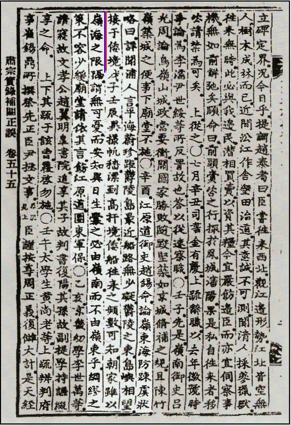
The July 22, 1714 passage from King Sukjong’s “Bogweoljeong-o” (補闕正吳)
A Korean 1714 report verifies Chosun cognizance of Dokdo and proves the islet weren’t Japanese.
In the year 1714 Koreans living on the east coast became very worried about Japanese who were straying into Chosun territory. The following historical document is quite short, however one simple sentence in the report has great significance in first verifying Korean cognizance of Dokdo hundreds of years ago. It also places the islets outside of Japanese territory and within the realm of ancient Korea.
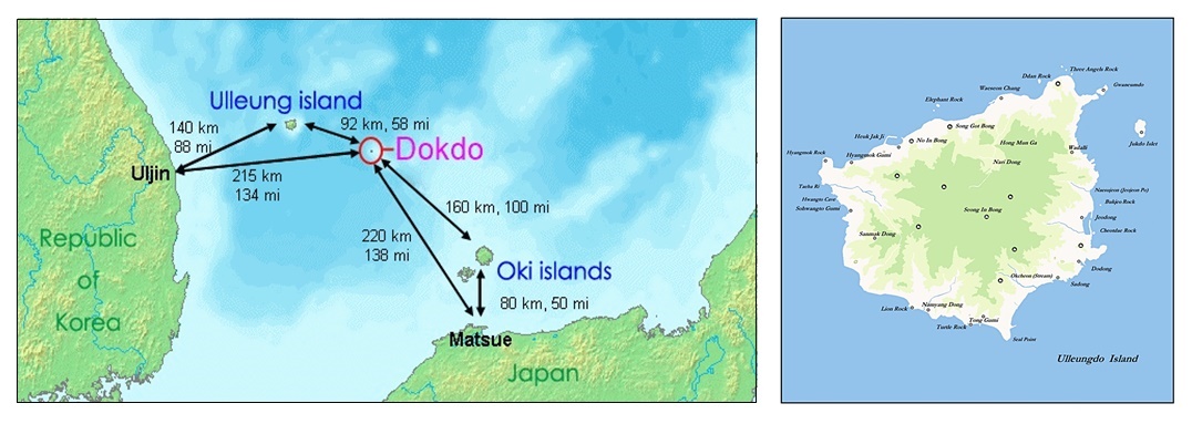
First this page starts with a map of the Korea, Ulleungdo, Dokdo and Oki Islands region. Korea’s historical claim to Ulleungdo goes back to the year 512. Dokdo Island is about 87kms away is visible from Ulleungdo three times a month on average. Dokdo Island is called Takeshima by Japan and sometimes referred to as Liancourt Rocks by some western nations.
Above left: A overall map of the Ulleungdo, Dokdo region. Above right: A picture of Dokdo Island from Korea’s Ulleungdo Island.
A Translation of King Sukong’s 補闕正吳 Entry, July 22, 1714
辛酉江原道御使趙錫命 論嶺東海防疎虞狀略曰 詳聞浦人言 平海蔚珍 距鬱陵島最近 船路無少? 鬱陵之東 島嶼相望 接于倭境. 戊子壬辰 異攘帆穡 漂到高杆境 倭船往來之頻數 可知. 朝家雖以嶺海之限隔 謂無可憂 而安知異日生?之必由嶺南 而不由嶺東乎. 綢繆之策 不容少緩. 廟堂請依其言 飭江原道 團束軍保
Gangwon Provincial emissary Jo Seok-myeong (趙錫命) discussed the neglected coastal defenses in the Yeongdong region. He reported the following:
“…I listened carefully to the people in the ports (浦人) who said, “..Pyeonghae (平海) and Uljin (蔚珍) are closest to Ulleungdo, and there are no obstructions along the sea route. Visible to the east of Ulleung is an island that is adjacent to the limits of Japan…” In 1708 and 1712, strange-looking ships drifted to the borders of Goseong (高城) and Ganseong (杆城), so we know that Japanese ships frequently come and go. The government, however, says that the vast sea is a barrier, so there is no need to worry, but how can we be sure that a future war will not break out in the Yeongdong region instead of the Yeongnam region? We cannot allow even a little delay in taking measures to be thoroughly prepared.
In accordance with the request, the Myodang (廟堂) requested that Gangwondo be reprimanded to cracked down on its military officials…”
A Conclusion Based on the Evidence King Sukong’s 補闕正吳 Entry, July 22, 1714
It’s surprising that such a short historical record could yield such valuable data. So what exactly does the 1714 report clarify for those interested in the Dokdo Takeshima historical debate?
First, this document tells us Korean residents of the coastal regions were cognizant of Dokdo Island long before the Japanese annexed the islets in 1905. It also shows despite Chosun’s vacant island policy on Ulleungdo, Koreans ignored this travel ban and still frequented the area. Thus the Ulleungdo area was never really abandoned during Chosun’s empty island policy toward Ulleungdo.
Additionally, Dokdo’s visibility from the shores of her nearest island (Korea’s Ulleungdo) are once again confirmed by this record. Some Japanese have steadfastly maintained Dokdo is not visible from Ulleungdo, however numerous records and images on this website have disproved this. (link)
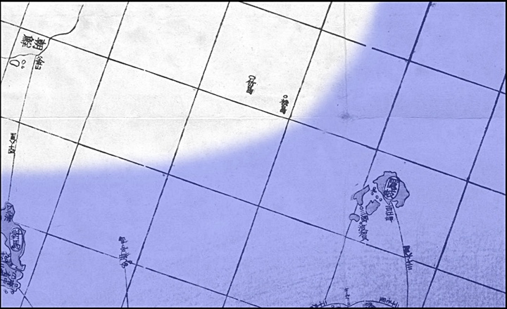
Lastly, the 1714 records makes it clear 18th Century Koreans excluded Dokdo from Japanese territory. Korean Emissary Cho Seok Myeong stated the island to the East of Ulleungdo was “adjacent to” or “bordering on” the limits of Japan and not part of Japan. This is in accordance with Jang Han Sang’s description of Japan’s limits when he wrote the Ulleungdo Sa-jeok in 1694. (link) The map below illustrates what would have been considered the territorial limits of Japan and Korea based on the records we have.
A Japanese Map, Altered to Illustrate Ancient Japanese – Korean Territorial Perceptions
The above Japanese historical map has been colorized to illustrate the territory of Korea (uncoloured) and Japan (blue). Ulleungdo (竹島) and Dokdo (松島) were part of Korean land. This can be verified through numerous historical records (see links below) (click map)
To understand this record clearly we should understand who it quotes. The residents of Korea’s coastal (Pyeonghae and Uljin areas) of course, had no modern concept of a linear national boundary as we understand today. However, looking eastward from Chosun’s Ulleungdo Island they knew there was a hostile neighbour (Japan) somewhere beyond Dokdo Island. Having never actually voyaged to Japan, none of these Korean fishermen would have had an idea exactly how far away Japan really was.
If indeed these Koreans thought Dokdo was Japanese territory this record would have simply stated so. However, it reads the island to visible to the East (接) “leads to” “borders on” or is “adjacent to” the limits of Japanese territory. This would be from the Korean perspective of looking East from Ulleungdo and beyond Dokdo. Clearly the “island to the East” (Dokdo) was en route to the limits of Wae-Gyeong (倭境-Japanese) land and not part of Japan itself.
In itself King Sujong’s July 22nd 1714 Entry (補闕正吳) is a powerful record. However, when cited along with the Ulleungdo Sajeok, Inbashu and Hoki’s letter to the Shogunateand Hachiemon’s Takeshima Incident there can be no doubt. Dokdo Island was within the realm of Korea. Dokdo – Takeshima Island was also consistently excluded from the territory of Japan by both Koreans and Japanese alike.