In this three page series however, original historical records from three of Japan’s battle cruisers the Niitaka, the Tsushima and the Hashidate help to remove the veil of secrecy that once concealed the motivation behind Japan’s claim to Dokdo. The ships’ records are arranged chronologically to show how the Japanese Imperial Navy systematically surveyed, mapped and zoned Dokdo Island before the island was finally integrated into Japan’s war plan against the Russian Navy during the Russo~Japanese War of 1904~1905.
The Tsushima’s records could be said to be a “smoking gun” of sorts for Korean historians who assert that Japan’s annexation of Liancourt Rocks (Dokdo) was nothing more than a military annexation. The November 1904 logbook predates Japan’s annexation of Liancourt Rocks (Dokdo Island) it also clearly reveals how the Japanese warship Tsushima surveyed Dokdo for military watchtowers and telegraph stations that would be linked to Korea’s Ulleungdo Island and Matsue, Japan in Shimane Prefecture.
October of the 37th Year of Meiji (1904)
The Logbook of the Warship Tsushima
Page 2.
“At 1:30 P.M. the Takechiho departed toward “–” and “–” gu. At 1:50 P.M. the Naniwa returned to Ojaki. At 3:45 the Chihaya arrived from “-” gu. At this afternoon the Second Fleet left the Yagumo behind at “–” gu and the rest sailed off to remain home…”
Saturday, October 22nd (Takeshiki)
A.M. B NW 4 -2 30.25 30.14 59.52
P.M. BC NN – W – 1
“Today other ships conducted battle drills (trumpet and firing). At 7:15 A.M. the Niitaka arrived from Daeryun. We received confidential order #259. The summary is as follows (below)..
“Instructions given to the Commander of the Warship Tsushima October 23rd, 1904. Depart by tomorrow at your convenience. Arrive at Matsushima (Ulleungdo) on the morning of the 24th…”
“…and get involved with the same watchtower extension construction and accommodate a number of workers. Also make a stop at Jukpyeon and Ulsan to receive a number of people for the same watch tower extension work and return…”
Sunday, October 23rd from Takeshiki to Ulleungdo
A.M. BC NE 2 30.32 29.22 62.50
P.M BC NE SW 1 -2
Physical Examinations
“At 9:30 A.M. departed from Takeshiki bound for Matsushima (Ulleungdo)
Monday, October 24th near Ulleungdo.
A.M. BC SW 3 – 4 30.14 65.61
P.M BC NW 4 – 1
“At 7:00 A.M. we neared the East watch tower on Matsushima (Ulleungdo). While drifting, lowered life rafts from positions #1 and #2, and started to pick up workers strong winds and high waves made the job very difficult….”
Page 4
“…and at 10;30, finally after a long struggle, succeeded in getting all the workers on board. Then sailed off toward (Ulleungdo’s) West watch tower at 11:25 and lowered life rafts of #1 and #2 and started to load workers. At noon the work was done and we started to sail off to Jukpyeon Harbor.
The number of workers assigned to Matsushima (Ulleungdo Island)
The East watch tower : 23 (workers)
} Total 41 Workers
The West watch tower :18 (workers)
At 5:00 P.M. we arrived at Jukpyeon Harbor and dispatched lifeboats of #1 and #2 to pick up laborers and one engineer. At 6:00 P.M. we departed toward Ojaki with them on board….”
Tuesday, October 25th From Urujaki (Ulsan) to Takeshiki
A.M. UC SE – NW 30.26 30.14 70.61
P.M. BC NW
“At 8:30 A.M. we arrived on Urujaki (Ulsan) , dispatched lifeboats #1 and #2 to pick up 13 laborers and at 9:40 departed for Takeshiki. At 4:15 P.M. temporarily anchored at Ojaki. Disembarked the picked up workers and then at 6:00 P.M. arrived on Takeshiki. A list of warships moored there are as follows:
On Ojaki: Ijeumo, Ajuma, Yagumo, Takachiho, Anpyeongseon #1 and #3, Ko – Oh – #67
On Takeshiki: Naniwa, Chihaya, #2 and #4, the 11th Fleet, the 17th Fleet.
Wednesday, October 26th Takeshiki
A.M. BC 0 – 1 30.23 30.15 66.58
P.M. B 0 – 1
“At 7:00 A.M the ship Chihaya departed for “–” and “–“. The ship Kasuga Maru arrived from “–“. At 12:50 P.M. the ship Naniwa departed for “–“. At the same time our ship returned from Ojaki.
Page 6
November 37th Year of Meiji
The Logbooks of the Warship Tsushima
Page 7
“At 1:40 P.M. we departed for “–” gu. At 5:30 we inspected an English boat “Long Ships” upon boarding at the position of 9 nautical miles southeast of Kanjaki. The English ship left Shanghai at noon on the 9th and was headed for Koubae. With nothing suspicious found the boat was released. (The cargo consisted of cotton and miscellaneous cargo). Today we also conducted fire drills. The ship Yagumo was incorporated into the 3rd Fleet. the ship Tokiwa was reassigned back to the 2nd Fleet. Patrol ship c departed.
Sunday, November 13th On high level alert as we patrol the Tsushima Strait.
A.M. OCR SSW 2 30.23 30.03 67.63
P.M. BC SSW 2
“At 3:20 P.M. we arrived at Takeshiki (naval base) and conducted a physical examination of the whole crew, and strengthened each division. We received confidential order #275 as follows”
“Order to the fourth corps, November 13th of the 37th Year of Meiji. Return from Takeshiki.
In accordance with confidential order #698, from command let the patrol duty of the fourth corps be changed as follows and for the time being, with the four ships below, serve your duties for three days from the day after tomorrow, the 15th. Also keep a watch out for smuggling ships and the fleet “Orajiyo” Let the flagship be either a temporary A or B patrol ship and use four ships for a rest or a checkup.
(a) Patrol ships are attached.
(b) Patrol ships of CFG are dispatched by order.”
“Received the confidential direction #276 as follows:
“Instruction to the commander of the frontrunner Tsushima. November 13th of the 37th year of Meiji (1904) Takeshiki, the ship Kasagi.
1. Officers must find out the source of workers and materials coming from different places upon their arrival and let your duties be served. As for the order of return and the quota for the day consult appropriate official directly to report the decisions of each ship.
(a) Inform of the test of the wireless telegraph communications of Takasaki Mountain along with the test technician.
(b) Survey Liancourt Rocks (Dokdo Island) for its suitability for telegraph installation (not wireless telegraph)
(c) Dispatch workers and materials for Matsushima, (Ulleungdo) Jukpyeon, and Cape Ulsan watchtowers.
2. Those workers and materials for the watchtowers above (Ulleungdo, Jukpyeon, Ulsan) are to arrive on the morning of tomorrow, the 14th….”
“Everybody arrived from Sae-ryu-maru. We headed for the Takasaki Mountain wireless telegraph station. The test technician is supposed to arrive on the morning after tomorrow, the 15th.
Monday , November 14th (1904) Takasaki Mountain
A.M. BC W1 30.01 29.92 63.56
P.M. BC WNW – W 2 – 5
Supplied with coal and water. At 1:00 P.M. we departed for Naniwa. At 6:50 arrived from Takachiho. Second Lieutenant “Haya Saung left the ship.
Tuesday, November 15th Takeshiki
A.M. BC NW 2 – 3 30.10 30.04 51.49
P.M. BC NW – W4
At 1:00 PM departed for Chihaya. At 2:05 arrived from Kasgamaru…”
Page 11
“Performed artillery exercises.
Wednesday, November 16th Takeshiki
A.M. BC NW 4 – 5 30.04 49 14
P.M. BC NW 4 – 5
Gales since noon of the 14th, they have hardly abated. The winds are continually blowing from the northwest. The maximum wind speed is about 6. The lowest pressure was 29.96 at 8:00 A.M. on the 14th and since then it has grown higher than 30.25 at noon. Received a warning at 4:20 this afternoon: “Sea storms are expected, be cautious with 2,3,4,5,6,7,8, and 10 districts of coastal regions. The low pressure is staying in cover the South coast. Approaching the northeast. Around the center are hurricane-force winds….”
“At 5:45 the depths of the waters 1.8 meters. Waves 3 meters high. At 1:40 P.M. the ships Ninawa and ~Muji arrived from Miura Bay.
Thursday, November 17th Takeshiki
A.M. BC NW 3 – 4 30.44 30.28 51 43
P.M. B B 0 – 1
At 10:00 A.M. we departed toward Takachiho Choko. We conducted artillery exercises and signaling. At 9:00 A.M. received a message. Learning of the warning to districts 2,3,4,5,6,7,8,9 of coastal regions, we departed from Oki for Tokigo….”
Friday, November 18th Takeshiki
A.M. BC G – 0 – 1 30.45 30 36 56 43
P.M. BC NW – W 3 – 2
“At 12:30 P.M. Kasuga Maru. At 2:00 we departed for Kasagi Choko. Bad weather for consecutive days has kept the official at Sasaebo (Nagasaki Naval Base) from coming. Thus confidential order #276 has been delayed from being carried out, but since he made it here today, workers and materials boarded at 3:10 and we parted from Ojaki at 5:30. We went to Jukpyeon Harbor….”
Saturday, November 19th From Ojaki to Ulleungdo
A.M. BC WNW 2 – 4 30.35 30.24 65 55
P.M. BC SW 2
“At 8:40 A.M. we arrived at the entrance of Jukpyeong Harbour. We lowered lifeboat #2 to land materials for watchtowers, sailed off to Matsushima (Ulleungdo) at 9:20, and temporarily anchored at 4:20 at Todong Port near the watchtowers on Matsushima…” (cont..
… to land materials for the watchtowers.
From the deck of the ship the grade of elevation is Todong Gak North 55 degrees East
Shiru Gak North 84 degrees West
Shiru Gak South 48 degrees West
The depth of the water is about 11 shim (1 shim = about 6 feet) And it has sand.
We measured the depth of the water around the port and found no danger.
Sunday November 20th From Ulleungdo to Liancourt Rocks (Dokdo)
A.M. BC 0 – 1 30.33 30.24 61 55
P.M. BC W 1
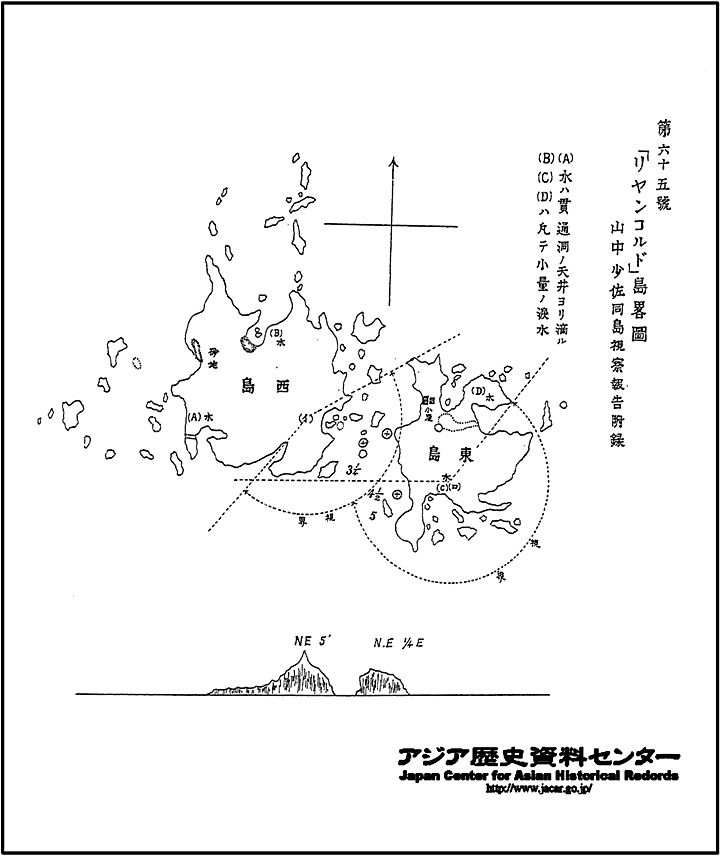
“At 7:20 we arrived at Liancourt Rocks (Dokdo). With the ship floating, Bu-jang-so-ja (high ranking naval official) Yamanaka Shibakichi and Eui-jang-dae-gun (another officer) were sent for inspection. At 10:55 both officials returned and we sailed off for Oki Island…”
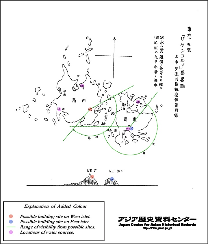
On the morning of November 20th 1904 Deputy Commander Yamanaka Shibakichi and a guard of the Tsushima conducted a detailed survey of Dokdo’s topography her surrounding geography for the purpose of building a military observation and telegraph station. The details of this survey are recorded in the Japanese Defense Historical Archives. The original documents and translation are below. It should be emphasized, all of these activities took place before the Japanese annexed Dokdo Island in February 1905, still during the largest war to the day.
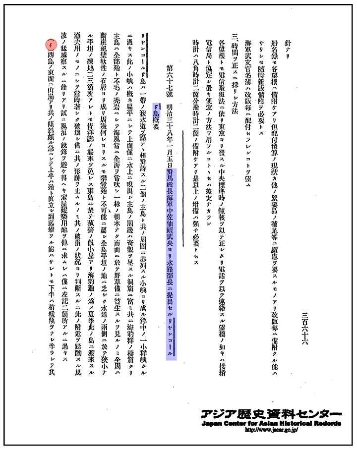
“…Liancourt Rocks are only a small island consisting of two main islets facing each other and surrounded by little rocks. These small rocks are mostly flat, and the tops are slightly above the surface. Around the two main islets are a number of small caves, were groups of sea lions inhabit. The main islets are just bare rocks without any trees, and a lot of wild grass in on the southern side like moss. There are sea winds blowing all of the time. Climbing is impossible from anywhere all around because of their precipitous cliffs and soft layers. There’s no level ground, both sides of the water passage between the two main islands are so narrow. There are a couple of flat stone areas but none of them are safe from the waves. On the East islet stands a little hut, which is used by fishermen to catch sealions in the summer. Now only the ruins of it lie after its sudden destruction. Judging by what is left of it, one can only imagine how powerful the winds and waves must have been when the damage was done. …”
(a) On the East side of the West Islet stands a peak whose side is so steep that the upper part cannot be climbed upright, but the lower part is gradual enough to make the way up to the middle of it. Geologically it is made up of strong stone here, and about 3 pyeong (unit of land) of level area can be made of it if some work is done on it. Winds from every direction can be blocked except from the East.
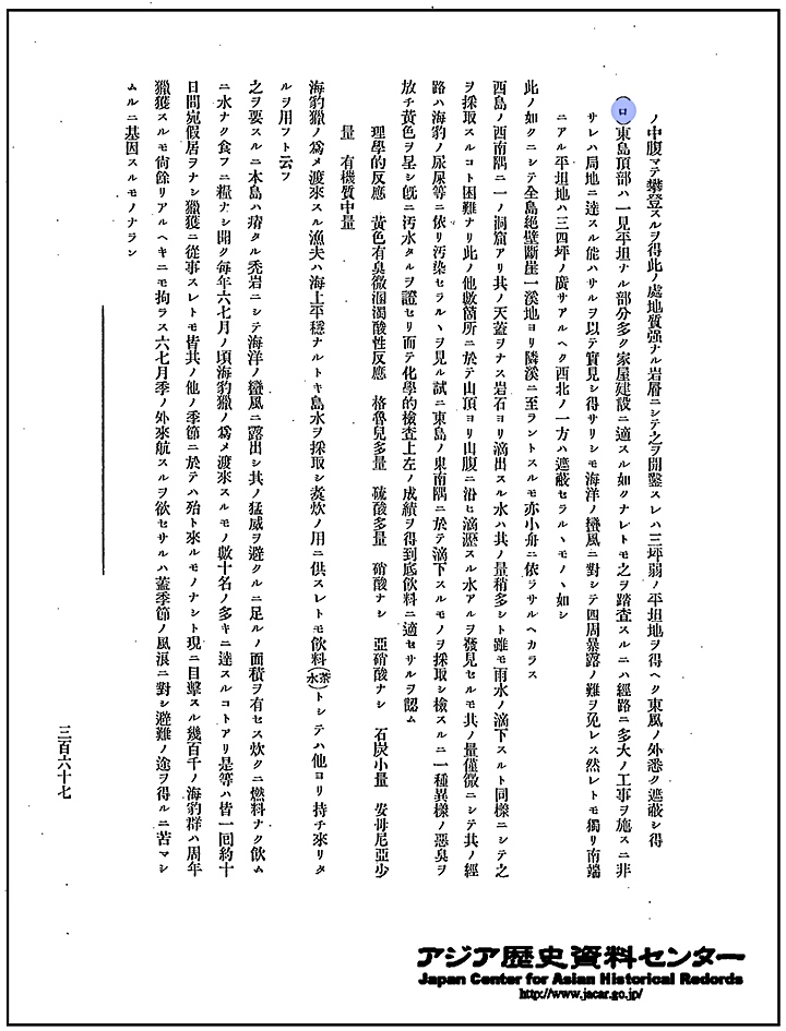
(b) At first glance the top of the East Islet seems to have a number of flat areas, and thus seems to be suitable for construction of structures. However, a survey of this islet reveals that an enormous amount of construction is needed for a path to access a certain area. Although it is inevitable that the islet is exposed to, and thus affected by bad weather, on the South is a flat area of about 3~4 pyeong (a unit of land), and one side of the northwest appears to be isolated…”
Physical properties: Clay brown, emits odour, murky and acid reactive. Chlorine: large quantity, Lactic acid: large quantity, Nitric acid: zero, Nitrous acid: zero, coal: small traces, Ammonia: small quantity, organic substances: medium quantity…”
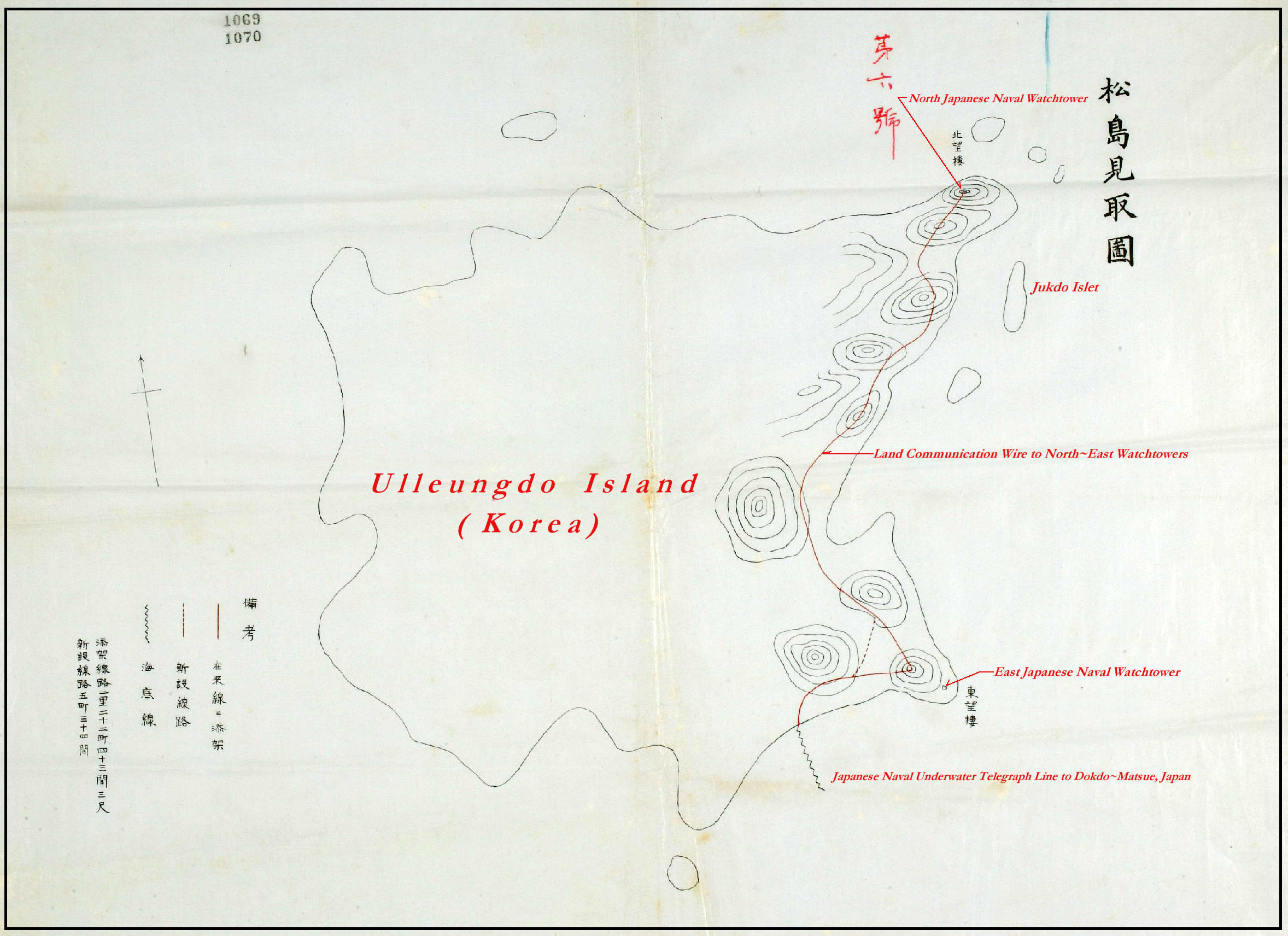
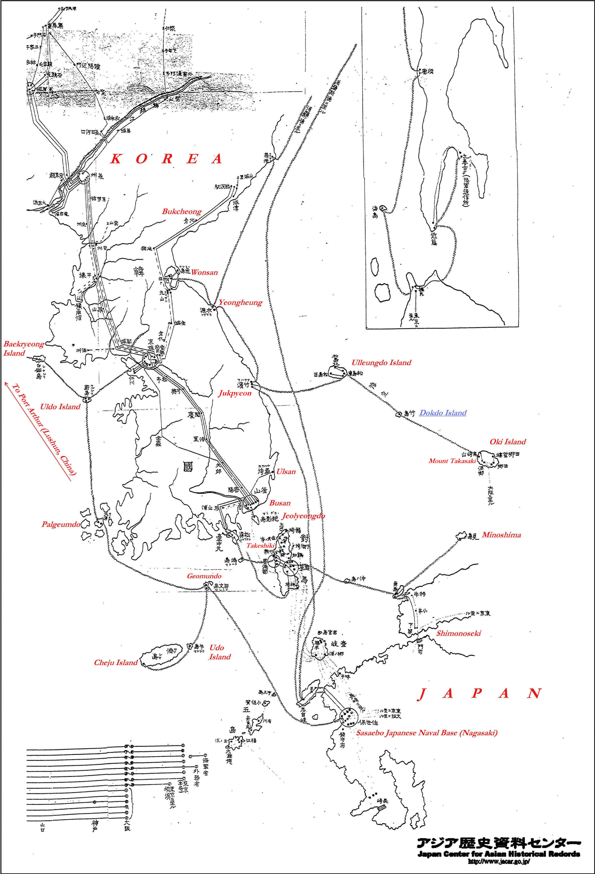 It wasn’t just Dokdo Island that was appropriated for military use. All strategic areas surrounding Japan including China’s Port Arthur area were utilized to defeat Russia. For example right is an overview of all underwater telegraph systems installed in Korea, Japan and China during the Russia Japanese War. Moving to the right, is a chart of Korea’s Cape Ulsan note the characters 望樓 for watchtower. In the center there can be seen map of Korea’s Jukpyeon Harbor again showing 望樓 for watchtower and 電信 for telegraph lines. Second from the right is a chart of Korea’s Ulleungdo Island. It shows two watchtowers 望樓 but later had another one installed. Telegraph lines were connected to Korea and Dokdo~Matsue, Japan. Far right is a Japanese military map of Takasaki Mountain on Oki Island where watchtowers and telegraph lines were planned to be installed. This idea was scrapped and the line installed directly to Matsue.
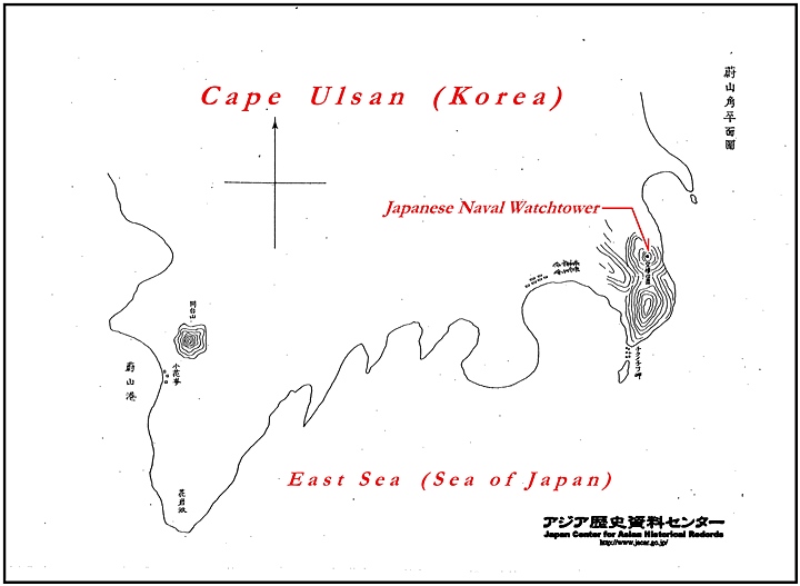

Thus, November 13th’s 1904 Confidential Directive #276 demonstrates the inseparability of Dokdo’s military annexation from the Japanese Navy’s appropriation of Korean territory and gradual annexation of the entire peninsula.
This submission of Dokdo’s survey takes us full circle to the Navy’s Hydrographic Department’s director Kimotsuki Kenko who was instrumental in guiding through the application of a private individual (Nakai Yozaburo) to lease Dokdo and have it incorporated in Shimane Prefecture. It is important to note, during the Russo Japanese War, the Japanese Navy’s Hydrographic Department became a strategic organ and provided critical information for directing naval military operations.
A career navy man since the age of 19 Yamanaka would be promoted to commander only a week after the submission of the report on Liancourt Rocks. By the year 1914 Yamanaka Shibakichi would reach the rank of Vice Admiral of the entire Japanese Imperial Navy.
In closing, the Tsushima’s survey is definite proof of Japan’s military motives for the annexation of Liancourt Rocks (Dokdo) This is obvious because these activities predate the actual annexation of the island in late February of 1905. Japanese Takeshima lobbyists would have the public believe these activities were an afterthought but as shown above with actual documents this can be dismissed as an obvious denial campaign.
Hopefully the records above can set the record straight on this dispute. The public can then decide for themselves whether or not Japan’s claim to Takeshima was a part of a natural, peaceful process as the ICJ requires for the acquisition of new territories. However, if Japan’s claim is wholly based on a military annexation at the height of a major war, it’s doubtful she will ever muster much, if any, international support at all.