A Study of British, Russian and Japanese Naval Maps and Dokdo – Takeshima
Japanese and Russian Naval Maps Label Dokdo as Part of Korea’s East Coast
 The following page is a detailed analysis of Russian, Japanese and British maps of the Korean East Coast in order to understand these countries relationship with Dokdo Island and their territorial perceptions. Dokdo Island is sometimes called Takeshima by Japan and Liancourt Rocks. In the Russian map that follows they were given different names.
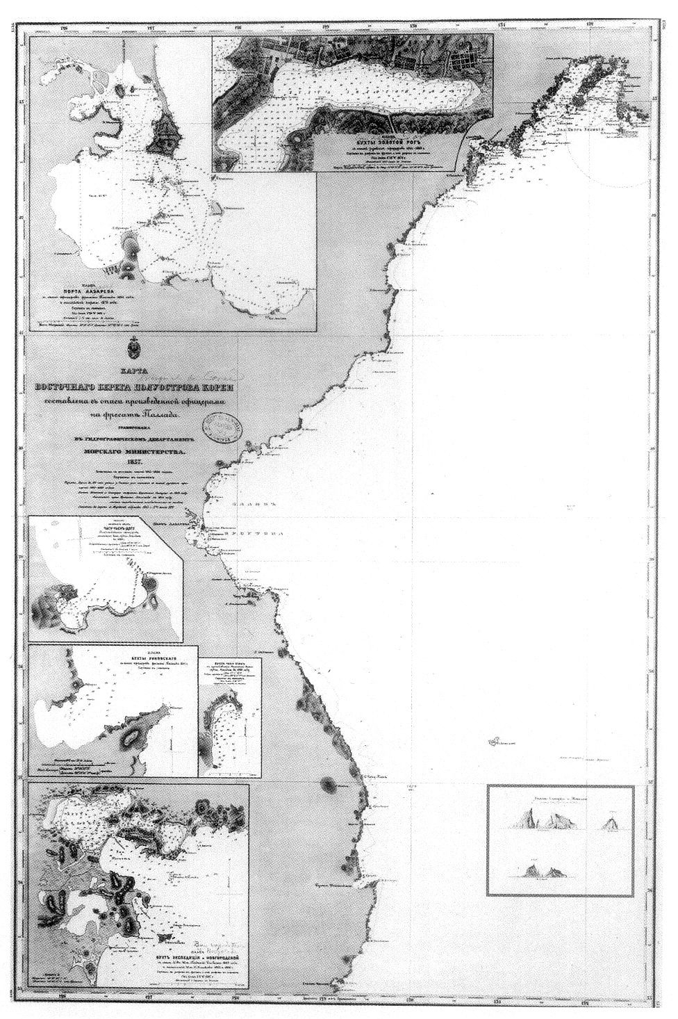
In the late 19th Century the colonial powers took a major interest in Northeast Asia and also Korea. Being the most proximate and expansionist at the time both Russia and Japan began to feverishly survey the region in detail. The map on this page was based on an 1854 survey by the Russian Navy’s Putyatian Fleet. The title of the map is the East Coast of Chosun and includes both Ulleungdo and Dokdo as part of Korea.

Far Above right: The overall image from the 1857 Russian Naval Map of Korea’s East Coast. Above: A close-up image of the drawing of Dokdo from the map. Distances and directional references are also drawn in.
During this survey the Russian fleet had Dokdo drawn from three positions and distances which is the map below. The top left image is Dokdo as seen from a distance of 6.5kms the bottom left is from 9.3kms and the top right is Dokdo Island as viewed from 26kms away. All images are as seen with the naked eye. The map shows Ulleungdo named as Matsushima. Dokdo’s West islet is named Olivutsa and the East is called Menelai.
The Japanese Version of the Russian Naval Map Dated in 1876
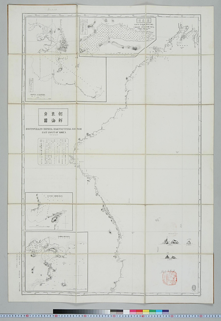 The map to the right is a Japanese copy of the Russian Navy map above. This chart shows us a few things. We can observe fictitious Argonaut Island drawn in dotted lines along Korea’s coast. This indicates the existence of this island was considered nill or “position doubtful.” The same could be said for the small rock on Ulleungdo’s northeast shore also drawn in dotted lines and marked as “P.D.” Also included are identical copies of the Russian sketches of Dokdo Islands with the Russian names drawn in Katagana.
The Japanese Navy copied and translated the Russian map practically to the letter and even drew in identical ocean depths, elevations and distances. In addition the map’s title East Sea of Korea indicates both Ulleungdo and Dokdo were appended as part of Korea as no territory of Japan is included on the naval chart.
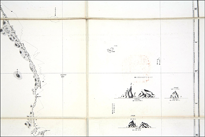
Far Above right: The overall view of the Japanese Naval Map. Above: The Japanese version of the Russian Naval map included a the close-up sketches of Dokdo with identical visual distances indicated below.
The 1857 Russian Naval Map and Japanese Counterpart – A Conclusion
The Russian Navy’s map is the first Western map that clearly shows both Ulleungdo and Dokdo as part of Korean territory. The images of Dokdo from this map were also used in the French Navy’s maps as well in the year 1861 so it is quite clear the chart was referenced by other nations. Russia’s East Coast of Chosun was used for decades after, with the only alterations being appended detailed charts of Korean ports.
Because of the map’s great accuracy, the Japanese Navy translated it without alternation in their 1876 naval charts. Thus it can be concluded Japanese were aware that Argonaut Island did not exist. Also, by not altering the map’s title or content, the Japanese acknowledged Dokdo was part of Chosun territory. This conclusion is supported by many other historical records and maps from the same time era, for example Mori Kinseki’s 1877 map on the next page.